

„A country of wonderful contrasts, hot deserts boundered by snowladen mountains, cinders and ashes scattered on glacier polished pavements, frost and fire working together in the making of beauty.“
John Muir
How, Where, What
Initially, only a ray of light penetrates the dense clouds and lands on the narrow plain in front of the Sierra massif. As if it wanted to tickle the land. You hardly notice it, after all your concentration is on the ever-jostling trucks that populate Rt-395. You drive on, and at some point, chance allows the sun to shine through a few large holes in the clouds, letting its rays patter down onto the grassland in mighty bundles. There and there, here in front and there behind. No waking eye can miss it anymore. This is the moment when you bring the car to a speechless halt on the shoulder, breathlessly grab your tripod and backpack, and, dust plumes or not, rush into the not-so-clear shooting position. Above it all, the black shadow band of the peaks, Ansel Adams‘ Range of Light, which this spectacle probably no longer stirs.
This serves as further evidence of the breathtaking beauty of the Eastern Sierra. But it gets even better. Mono Lake surprises with extraordinary tuff formations on its shores. Calcium rising from underground springs mixes with alkaline (carbonate-rich) lake water to form tuff, which then deposits around the spring to form a turret. The lake water is about two and a half times saltier and a thousand times more alkaline than the ocean. The tributaries draw both from the ancient lake beds and the volcanic lava fields they cross. Since the water has no outlet and evaporates, the substances have accumulated over time. Tragically, Los Angeles County’s immense water needs are the reason we see these formations. Unrestrained use of the tributaries since 1941 has lowered the water level by 15 m (49 ft) by 1994. This corresponded to a reduction of the lake surface by almost 50 %. In 1994, new protection mechanisms halted this vibrant activity, setting a target water level of 1948 m (6,392 ft) above sea level. Several more years will pass before the water level reaches this target, at which point most of the fragile formations, formed at least 200 years ago, will have vanished back under the water. For comparison, the photographs represent a level of 1945 m (6,384 ft). So the window of opportunity to photograph the lake with its major attractions is slowly closing.
Something that remains even then is the large number of birds that visit this area every year. Among many other species, nearly the entire California gull population nests on the two volcanic islands in Mono Lake in the spring. Other flocks rest here and gorge themselves on the abundant shrimp for the journey to winter quarters.
Another unique feature of Mono Lake is its color change from light green to light blue between winter and summer. It is caused by the large number of algae that multiply rapidly during the winter and provide the green color. Then, as the water warms in the spring, shrimp and alkali flies multiply to eat the algae. By summer, they are so successful that the water is clear and blue again.
Mono is the Yukat Indian word for the swarms of black alkali flies that grow magnificently in the lake each spring.
Geographical orientation and the most photogenic times of day
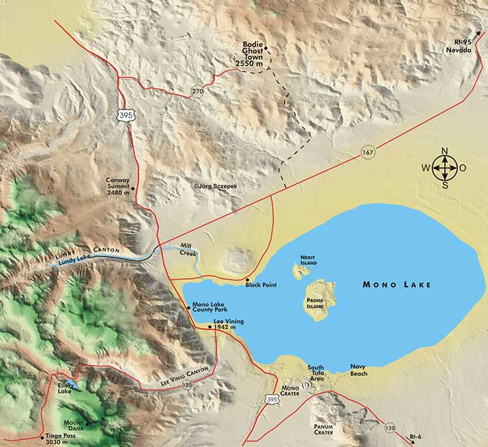
Mono Lake is located on a wide plain open to the east, bounded by the high Sierra Nevada range to the west. This prevents the light from shining early in the evening, which would otherwise highlight the formations at the lake. However, before sunrise, you can place the tuff formations in front of the Basin Ranges chain against a purple sky to the east. Only moments later, the sun then has free course to bathe the fragile, almost colorless towers and peaks in the west simultaneously in the finest light.
A strange smell hangs over the small town of Lee Vining, like the intense scent of the sea
Motifs around Mono Lake
The south shore of Mono Lake offers the largest number of tufa formations. In the fine, reddish morning light, the formations there in the South Tufa Area appear almost friendly. But the higher the sun climbs, robbing them of their makeup color along the way, the more ghostly the tall towers look against the blue sky. Access the area via Rt-120, which branches off Rt-395 8 km (5 mi) south of Lee Vining, and follow it west another 8 km (5 mi) to the fork in a dust road. Turn left here to South Tufa Area, then right to Navy Beach. To the south, you will see the volcanic cones of the Mono Craters. At South Tufa Area, you can walk a 1,6 km (1 mi) trail through the landscape of near-white formations reaching the shore, get close enough to them for macro studies, and combine them with the glowing mountains to the west at sunrise. Clouds sometimes make subjects better and sometimes worse. Here, they first help provide the necessary illumination in the evening, as they reflect the sunset light shaded by the sierras onto the lake, giving the water surface an almost ethereal appearance. On the other hand, if the sky is clear, you can still catch the changing moods of light on the plains and ridges to the east.
At nearby Navy Beach, you’ll find small sandstone formations created when underground calcium springs bubbled through a layer of salty sand.
Mono Lake County Park, located off Rt-395 via Cemetery Road, boasts more tufa formations on the west shore of the lake, although they are not as remarkable. The formations there just barely overhang the water level and are very widely spaced.
The area around Black Point to the north is dotted with large fissures that suggest volcanic activity. It is also conveniently located for observing bird colony activity on Paoha and Negit Island.
Lundy Canyon, 11 km (7 mi) north of Lee Vining, is one of the best places in the area to record wildflowers in July and fall birch colors in mid-October. Just across Rt-167, Lundy Road branches off Rt-395 and follows the course of Mill Creek west for 8 km (5 mi) to Lundy Lake and the resort complex of the same name. Here the asphalt ends and the route turns into a passable dust road. After another 2,5 km (1,5 mi) you have reached the beginning of the Lundy Trail. It takes you barely 2 km (3,2 mi) along the creek and past some beaver ponds to the 60 m (197 ft) high Lundy Falls. This waterfall, like others nearby, is most impressive during spring snowmelt. Creative long exposures capture the water’s movement, which perfectly complements the autumnal foliage colors, revealing their full richness of tone under an overcast sky. The interior of the small canyon receives the best direct light in the second half of the day, especially in the late afternoon. Thus, Lundy Canyon complements the formations at Mono Lake perfectly and makes for a full one-day visit to the area. Even though the gold rush in this area was brief, significant gold-bearing ore mining occurred here only between 1879 and 1884, leaving behind some remarkable relics from that era. So with a little more time, you can still explore the remains of the old gold mining town of Lundy at the west end of the lake, some of which are inhabited during the summer months, and the legacy of the May Lundy Mine operation in the surrounding mountainside.
Mono Lake is a record holder; at more than 700,000 years old, it is the oldest lake in North America.
17,5 km (11 mi) north of Lee Vining is Mono Lake Vista Point on Rt-395. Just below Conway Summit, it is already decently high at 2469 m (8,100 ft). It offers a spectacular view south across Mono Lake, especially in the late afternoon when the low eastern sun enlivens the plain with long shadows and bathes the Sierra Nevada mountain fortress to the west in soft light.
Next Photo Tips Bodie Ghost Town
Main Photo Tips USA – California
Previous The Bristlecone Pines in the White Mountains
If you found this post useful and want to support the continuation of my writing without intrusive advertising, please consider supporting. Your assistance goes towards helping make the content on this website even better. If you’d like to make a one-time ‘tip’ and buy me a coffee, I have a Ko-Fi page. Your support means a lot. Thank you!
 Since I started my first website in the year 2000, I’ve written and published ten books in the German language about photographing the amazing natural wonders of the American West, the details of our visual perception and its photography-related counterparts, and tried to shed some light on the immaterial concepts of quantum and chaos. Now all this material becomes freely accessible on this dedicated English website. I hope many of you find answers and inspiration there. My books are on