

„I never tire of that wonder spot, nor could I ever forget it, no matter where I go from here. … I decided to work with cypress for the first time in months: The sun on their weather-polished trunks reveals every tiny line, etches black on a surface glistening as ivory. – Harder to isolate details of a cypress than to work with rocks.“
Edward Weston, My Camera on Point Lobos
How, Where, What
Prior to my arrival, my only familiarity with Point Lobos came from Edward Weston’s photographs. Images that depict something essential both about the world and about us. These principles were unconscious and somewhat hazy, yet they held immense power. In my mind, this was a mythical place in the classical sense.
Modernity ascribes to the word myth something that sounds like „fantasy“ or „fable.“ In its classical definition, however, the term has a deeper meaning. It is rooted in the Greek musteion and means something like „to close one’s eyes or mouth.“ In this sense, myth is rooted in an experience of darkness and silence. Something that lies at the center of our soul. Myths plumb this inner depth, telling us in metaphors and symbols of something that is fundamental to ourselves: of enduring, essential, and universal laws, of things that are true and connect us to the most essential facets of ourselves. To experience them requires more than the use of the conscious mind and logic.
Weston’s images are such metaphors. In the ability to see them and hold them for us lies this man’s very special skill. And Point Lobos is full of such metaphors. The trunks, branches, and roots of the cypress trees, the rough and fine forms of the rocks, the patterns of the kelp, and the shapes of the crashing waves, all speak at first glance of wind, rain, cold, and heat. Of natural forces to which we do not expose ourselves and which we thus experience only imperfectly. At second glance, however, they reveal an all-connecting symmetry and order and, although sometimes frightening on their own, in their totality, the certainty of being in good hands.
In this respect, we can be grateful to nature for having given us the wild coast of the Point Lobos Peninsula. The Spanish called the area Punta de los Lobos Marinos, or Cap of the Sea Wolves. We don’t call them wolves, but sea lions, and they are still present here. Here we encounter the rocky coastline, the unpredictable surf, the coves of clear turquoise water, the steep, craggy cliffs, and the gnarled Monterey cypress trees whipped by the wind into the most impossible shapes that make the word „magnificent“ seem the only appropriate one. – Forget the thoroughly commercialized and crowded 17-Mile Drive™ on the western part of the Monterey Peninsula – Point Lobos offers the same subjects in a quiet and unspoiled setting.
Established in 1933, the park’s initial purpose was to protect the unique stands of Monterey pines and Monterey cypresses. In 1960, it was expanded to include the intertidal zone and the first underwater nature preserve in the United States. What appeals to us most are the different colored granites (black, brown, beige, almost white) and the rare Monterey cypress trees against the backdrop of spectacular surf. In addition, on a clear day, there are beautiful views of Carmel Bay. After some contemplation on the beaches, one can find many beautiful still lifes in the rocks and flotsam. In addition, there is a rich fauna whose most outstanding representatives are the cute California sea otters, the gray whales that pass by between December and May, and the mighty California sea lions.
Summer days are pleasantly warm, sunny, and dry, with frequent fog between July and September. The winter months bring occasional rain but much less fog than the other months. The low sun’s flat light enables the exploration of the reserve’s numerous subjects throughout the day. In spring, colorful wildflowers spread across the meadows.
Directions
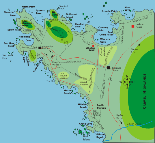
Point Lobos is located 6,4 km (4 mi) south of Carmel, just off Rt-1. The reserve remains open daily from 08:00 until approximately one hour after sunset, as posted at the entrance, to provide the native wildlife with an undisturbed feeding time. The information station is staffed between 09:00 and 17:00. The maximum number of visitors in the small reserve is limited. So plan in some waiting time as a precaution, because if this number has already been reached, you will have to wait at the entrance (“one-vehicle out, one-vehicle in”). The preserve is usually precluded on weekends and vacations. During this time, a line forms at the entrance as early as 08:15. Visitors with vehicles must pay a fee; pedestrians who have parked their ride at Rt-1 may enter for free. No vehicles longer than 21 ft are allowed in the preserve. There are nine designated parking areas, a few miles of paved roads, and 24 km (15 mi) of designated trails. Within the protected area, there are no utilities except picnic areas, toilets, and water points. You can find these amenities, along with hotels and campgrounds, in nearby Carmel and Monterey, a short distance away.
Geographical orientation and the most photogenic times of day
Point Lobos, facing west toward the ocean, naturally serves as a foreground for the low afternoon and evening sun. This is fortunate, as the late 08:00 entrance time and the 1200+ m (3,900 ft) Carmel Highlands to the east, which shade the morning sun for a long time, prevent you from taking advantage of sunrise here any day of the year. Even for sunset, the time frame is tight, as you need to be out ½ hour after sunset, as described.
Photographic specialties
Because of the wide variety of subjects, you should bring your entire arsenal with you to Point Lobos. Short focal lengths down to 18 mm for landscape photography. Long focal lengths up to 400 mm (or even longer if available) for wildlife photography. A 50 mm macro or equivalent for close-ups and still life. If the lighting conditions are too harsh, you can also benefit from a foldable reflector or fill flash. A polarizing filter helps reduce reflections on the water surface.
Motifs in the interior of the peninsula
Whalers Knoll overlooks the peninsula and affords a good panoramic view. During the whaling era, this hill served as a lookout post. Three trails lead to Whalers Knoll, one from the entrance station and two from the North Shore Trail. The former is the longest, measuring just 700 m (800 yd) with an elevation change of 50 m (54 yd). The pines here in the interior are draped with a distinctive gray-green lichen that resembles Spanish Moss but is actually a mixture of fungus and algae. The Lace Lichen Trail passes through a dense stand of such pines. In spring (mid-April through May), the meadows are dotted with colorful wildflowers. California Poppy, Shooting Star, and Indian Paintbrush are the most conspicuous.
Motifs on the north coast
The north coast is rocky, rugged, and high in elevation, but the bays there are calm and often shimmer in an impressive turquoise. This is an environment that sea otters prefer, as they spend almost their entire lives in the water and also feed and sleep in this element. With binoculars, you can make out the dark little „logs“ among the kelp – these are sleeping otters. And when it’s quiet, you can often hear that ping-ping-ping that occurs when the animals, floating on their backs in the water, bang a shell against a rock they balance on their belly to open it. Moss Cove and Whalers Cove are good places to observe and photograph these cute fellows. Since this area is quite high in elevation, you’ll need a long telephoto focal length in the 400 mm range to take format-filling portraits. Take advantage of this opportunity, because today the sea otters only occur in a few hundred along the 370 km (230 mi) coastline between Ano Nuevo to the north and Pismo Beach to the south. Here at Point Lobos, you can take them year round.
From Coal Chute Point, you can shoot the slightly weathered wooden structure of the Whalers Cabin with a telephoto focal length across Whalers Cove. It’s a good subject that combines the coastline, some of the area’s history, and the dense inland green vegetation. Chinese fishermen built Whaler’s Cabin around 1850, which now houses a museum. From there, you can often observe and photograph sea lions and otters. Granite Point, a little further along the Granite Point Trail, also overlooks Whalers Cove, but the distance is greater, so you can include more foreground. From the highest point on the Granite Point Trail, you can see across the sandy beach of Carmel Bay to Pebble Beach.
A side trail off the North Shore Trail leads to a viewpoint overlooking Guillemot Island. In spring and summer, you can watch seagulls and cormorans nesting on the island from there.
Just before the North Shore Trail crosses the Cypress Grove Trail, another turnoff (Old Veteran Trail) leads to a point from which you can take in a very special cypress tree: Old Veteran Cypress has a mighty crown and an extremely gnarled trunk. It clings to a rock face above Cypress Cove. From the end of the trail, a composition with a short telephoto focal length that just keeps the spray of the waterline in the frame is an obvious choice.
At the northern tip is one of two naturally occurring Monterey cypress groves, the wonderful Allan Memorial Grove. The Cypress Grove Trail circles it, giving repeated views of the particularly spectacular surf between the granite cliffs here. Many cypress trees here are covered with a red-orange-colored algae that contrasts nicely with the green of the trees. The specimens farthest out to sea are the most photogenic. Their roots claw into the bare rock, making one wonder if the salty spray is really their only means of survival.
As often as possible, use the branches of cypress and pine trees to frame the images, giving them greater depth.
Motifs on the south coast
The south coast is flat, with sandy beaches and tide pools. This is an environment to look for fine still life on the bottom: washed-up wood, small smooth polished stones, kelp leaves, and the large gas-filled floats of this kelp, seaweed, and a variety of shells. These are subjects for the soft light of an overcast or slightly foggy day. Under these conditions, the details and colors come out best. The direct, harsh midday light, on the other hand, provides too much contrast.
Good locations to capture the gray seals (they flock to this coast all year round) and the sea lions (their most extensive gathering regularly occurs during the two weeks in mid-April) are Sea Lion Rocks (you’ll need at least 400 mm focal length there because of the distance) and Sea Lion Cove (there, you can get relatively close to the animals via the Sand Hill Trail). This is also an excellent location for a shot that combines the prominent features of this landscape with a strong wide-angle: the coastline with its soft surf and the highlands of the Carmel Highlands to the south.
Along the South Shore Trail, there are a few places where the trail is not virtually „fenced in“ by markers that should not be crossed. There, you can move freely on the rocks. In any case, caution is advised because the rock is often slippery and the crashing waves are incalculable!
The Bird Island Trail leads from the Bird Island parking lot to a viewpoint with a good view of the island. Along the way, it passes China Cove and Gibson Beach, two wonderful white sand beaches. Both are accessible via long stairways. China Cove is one of the highlights of this area, as the water in this cove glistens jade green and the rock walls are decorated with hanging gardens. At Pelican Point, the trail passes through seasonally changing wildflower stands.
In many places in the Point Lobos Reserve, you will come across the conspicuous three-leaved tufts of the so-called poison oak. Keep away from them, as the oil responsible for the shine of the leaves causes an unpleasant, itchy rash that lasts for a long time. Long pants are a good idea to protect yourself from skin contact. As the plant also occurs in many other forms, it is best to ask the rangers about its appearance.
Minimum program and daily schedule
You can get a brief overview of the cypress trees in Allan Memorial Grove and the particularly beautiful China Cove in a good 2 hours, preferably in the afternoon. A full day is best utilized by spending the morning on the North Shore, walking the Granite Point Trail and the North Shore Trail. Lunch and early afternoon should be spent on the South Shore, Sea Lions Point, South Shore Trail, and especially China Cove before turning to North Point, Cypress Grove Trail, and Allan Memorial Grove with the sun low in the west.
Main Photo Tips USA – California
If you found this post useful and want to support the continuation of my writing without intrusive advertising, please consider supporting. Your assistance goes towards helping make the content on this website even better. If you’d like to make a one-time ‘tip’ and buy me a coffee, I have a Ko-Fi page. Your support means a lot. Thank you!
 Since I started my first website in the year 2000, I’ve written and published ten books in the German language about photographing the amazing natural wonders of the American West, the details of our visual perception and its photography-related counterparts, and tried to shed some light on the immaterial concepts of quantum and chaos. Now all this material becomes freely accessible on this dedicated English website. I hope many of you find answers and inspiration there. My books are on