

„The dim trail led us to its edge, where we could look down into the twelve hundred foot V-shaped gash which the river had cut into the dark, crude-loking archaean rock. How distinctly it looked like a new day in creation where the horizontal, yellowish-gray beds of the Cambrian were laid down upon the dark, amorphous, and twisted older granite! How carefully the level strata had been fitted to the shapeless mass beneath it!“
John Burroughs
- Elevations between 784 m (2,572 ft) at Phantom Ranch on the Canyon bottom and 2100 m (6,889 ft) at the South Rim or 2560 m (8,399 ft) at the North Rim
- On average, there are about 5 million visitors per year, of which only 10 % visit the North Rim
- Visitation to Grand Canyon is highest between March and April, from late May to early September, and during all major holiday weeks. August is the month with the highest number of visitors
„Kaibab“ was the name given by the Paiute Indians to the canyon: „Upside down mountain“. – The canyon is a record for half of the geological time scale!
How, Where, What
The first view over the canyon is simply breathtaking. In the morning and evening, the canyon presents itself as a landscape in its own right, a sea of shapes, colors, light and shadow, larger and more spectacular than one had dared to hope. The midday light, on the other hand, levels the dimensions in a peculiar way and robs the control of distance and size. Once you have grasped this understanding, the only question remains: How can you immortalize infinity?
Many forces have created this canyon landscape’s unique panorama, but the photographer is drawn to more than its vastness. Throughout the seemingly chaotic expanse of plateaus, cliffs, and temples, one can uncover details that individually create a unique, nuanced portrayal of this magnificent landscape.
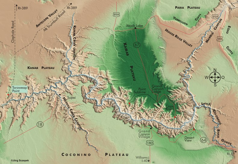
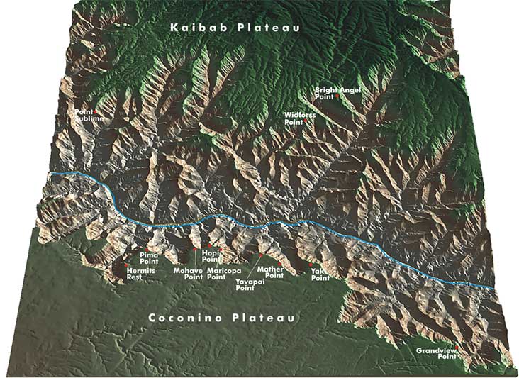
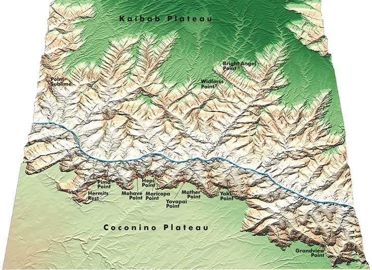
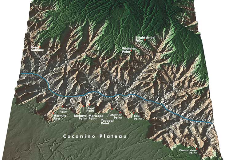
The magnificent Colorado River gorge runs from Glen Canyon Dam in the north into Lake Mead 443 km (275 mi) to the southwest. The portion of the canyon visible from established vantage points on the north and south rims enters from the north through Tanner Canyon, makes a wide arc around the jutting cliff of Cape Royal, and then continues west, offset very slightly to the north.
To the north, the 2700 m (8,858 ft) high Kaibab Plateau forms the rugged fault edge. In contrast, the surface of the Coconino Plateau in the south is plate level, drops comparatively steeply, and reaches only 2300 m (7,546 ft). The dense green blanket of the Kaibab National Forest covers both plateaus. In general, there is a 10°C (50 °F) temperature gradient between the south and north rims. On the way down to the bottom of the canyon, it gets warmer by an average of 7 °C (45 °F).
The highlight of the year is autumn, with the spectacular foliage coloration of the extensive forests that begin in October. The mostly bright blue sky then merges with the multicolored rocks, golden-crowned aspens and evergreen firs to form a wonderful whole.
Geographical orientation and the most photogenic times of day
The east-west orientation facilitates the photographic craft, as it makes all vantage points looking into the canyon almost equally suitable for capturing the panoramas and formations in the light of the low sun.
The first light of the morning illuminates the reddish-yellow limestone just below the fault line. A little later, one by one, the multicolored layers of earth become visible in the depths. The second half of the day reverses this spectacle, with shadows creeping back to the surface, engulfing colors and details until night fills this vast scar black.
Photographic features
The biggest problem at the Grand Canyon is translating its proverbial size into photographs. Panoramic views, quickly photographed from the next best vantage point at noon, are completely unsuitable for this purpose. The higher the sun, the shorter the shadows, and the flatter, contrastless, and one-dimensional the image becomes. Therefore, limit the work to the two hours after sunrise or before sunset. The most effective use of light is when your subject is facing the opposite direction of the sun. You should shoot large-scale overviews when the light is distributed by many small clouds and the sky is thus varied in structure. In addition to flat light, a foreground with active near and far points is another way to add depth and spaciousness to your shots. You can incorporate charmingly shaped juniper bushes and pines, which grow at almost all vantage points, into the image. Alternatively, consider positioning your travel companion(s) in the foreground, possibly using some flash lighting.
The canyon itself
The canyon interior is the third major area of the National Park, along with the North and South Rims, and unless you’re taking an inflatable boat from Lees Ferry, the only way to reach it is on foot. Several trails lead down from the North and South Rim. All of these trails share the common feature of bridging a significant altitude difference of more than 1000 m (3,280 ft) over the stretch of more than 10 km (6.2 mi), which in turn places significant demands on your personal fitness. The basic equipment includes food and at least 2 liters of water, both of which you should consume. In the Visitor Center, you can get detailed information about possible dangers and precautions. On the way, provided you have a Backcountry Permit, you can camp in specially designated areas of the park, called use areas. But just like overnight accommodations at Phantom Ranch at the canyon bottom, the number of permits is limited; usually the number of applications doubles the permits issued. Reservations for Phantom Ranch also run up to a year in advance. However, there are a not inconsiderable number of cancellations, and thus at least a chance for a short-term bed.
„The majority of Grand Canyon hikers are here for the first time, and although many are avid hikers, they find that hiking the Grand Canyon is very different from most other backpacking experiences. They tend to react to the experience in one of two ways: either they can’t wait to get back or they swear they’ll never do it again.“ www.thecanyon.com/nps/backpacking
One more thing about safety: if you encounter the mulicaravan carrying the not-so-well-constituted down and up along the way, step to the inside edge, stay calm, and follow the wranglers‘ instructions. – A spooked animal can easily cost someone their life if it runs away!
The walking times provided are minimum durations, excluding photo stops. Assuming an early start, it is generally possible to walk from the South Rim down to Phantom Ranch and back up again in one day (8–10 hours at a brisk pace). Always keep in mind that the steeper way back takes more energy and time than the downhill part.
Next Photo Tips Grand Canyon South Rim
Next Photo Tips Grand Canyon North Rim
Next Photo Tips Toroweap Point
If you found this post useful and want to support the continuation of my writing without intrusive advertising, please consider supporting. Your assistance goes towards helping make the content on this website even better. If you’d like to make a one-time ‘tip’ and buy me a coffee, I have a Ko-Fi page. Your support means a lot. Thank you!
 Since I started my first website in the year 2000, I’ve written and published ten books in the German language about photographing the amazing natural wonders of the American West, the details of our visual perception and its photography-related counterparts, and tried to shed some light on the immaterial concepts of quantum and chaos. Now all this material becomes freely accessible on this dedicated English website. I hope many of you find answers and inspiration there. My books are on