

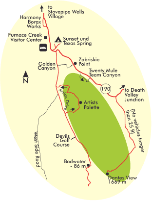
Motifs around Furnace Creek
You can gain insight into the challenges of borax extraction by taking a short walk through the ruins of the Harmony Borax Works, which dates back to the late 19th century, located just north of the Visitor Center. One of the many-wheeled carts of that era, pulled by 20 mules, is also on display here.
You can reach the 1669 m (5,475 ft) Dantes View, which is 42 km (26 mi) from Furnace Creek via Rt-190 and Dantes View Road (no vehicles longer than 25 ft). This is the highest road-accessible viewpoint above the valley, offering spectacular views along nearly its entire length. On clear days, you can see the peaks of the Sierra Nevada to the west. Directly below, but out of sight, is Badwater. A short hiking trail leads from the north end of the parking area up to the top of Dantes Peak. Morning is the best time to photograph, as you’ll be working with the sun and the air will be pure and clear. However, backlit situations in the evening also have their appeal.
Zabriskie Point is located 8 km (5 mi) south of Furnace Creek on Rt-190 and is prime for sunrise due to its location and surrounding landscape. From an elevated position, the view spans across the offshore badlands, where sedimentary hills have been eroded into soft shapes by rapidly draining water. It then extends to the bright floor of Death Valley and, to the west, the high wall of the Panamint Mountains. The scene becomes especially breathtaking when the rising sun first illuminates the high peaks, followed by the mountain flanks and the valley floor, and finally the formations with their soft flanks that appear to have been painted away. At this time, brightness differences of 5 f/stops are common and, depending on the image medium, may necessitate the use of a graduated gray filter for compensation. On different hiking trails, you get further down and right into the badlands. Additionally, from an elevated position, you can see the rise of the red sunball to the east. If possible, be here 20 minutes before sunrise to secure a good spot, and keep in mind that you need to allow 40 minutes driving time from Stovepipe Wells Village. 24 mm focal length captures the whole panorama; a medium tele condenses individual formations like Manley Beacon on the right, which the sun bathes in a deep orange hue.
A short path through Golden Canyon leads to Red Cathedral and Manley Beacon through the steeply diagonally folded layer packs, offering ample opportunity to bring the exuberant variety of forms into creative context with the surrounding landscape. Macros of the bright red or green inclusions in the rock are just as suitable as wide-angle shots with great depth of field. After 1,2 km (0.7 mi) through the main canyon, you reach a fork, whose left branch leads you to the Red Cathedral formation. It owes its bright color to the high percentage of trapped and oxidized iron. Via the right arm, you loop up to Zabriskie Point. Between the two trails, you will see Manley Beacon in an elevated position. It is best to walk this trail once in the morning to explore and again in the late afternoon to see the canyon walls and badlands off Zabriskie Point glow pure gold in the evening light. In the vicinity of the trailhead, 4,8 km (3 mi) south of Furnace Creek on Rt-178, there are similar badland formations to the left that are also good for sunset.
If it is very quiet, you can hear the fine salt crystals at Devils Golf Course crackling as they contract in the morning. 19 km (12 mi) south of Furnace Creek, the Death Valley salt pan is located here at the bottom of the Badwater Basin. Supplied by irregular floods of evaporating moisture, a vast field of enormously large yet fragilely small salt crystals has formed here. A fascinating macro world opens up to the heat-resistant photographer, which, with the large manipulable depth of field of a wide angle lens, can also be placed in context with the surrounding mountain ranges. Solid shoes and a base to kneel on are a must for getting into good, low shooting positions among the sharp-edged peaks. The old-fashioned accessory of an angle finder is also helpful. Digital cameras make it superfluous with their foldable LCD displays.
Sunrise or nothing! The same goes for Badwater just below Dante’s View. Everyone likes to be photographed with the wooden sign Lowest Point in Western Hemisphere, but the white bottom of the salt pan 32 km (20 mi) south of Furnace Creek is not favorable for really attractive pictures. Too close below the Amargosa Range and too far from the Panamints in the west. The only exceptions are days when a lot of meltwater from the higher elevations collects at this low point, forming a reflective lake for sunrise. In that case, use your shortest wide angle lens and position yourself as close and low to the pool of water as possible to capture the reflection of the sun’s first rays on the heights of the Panamint Range. Since this area of the image will in any case be brighter than the foreground, which is still in shadow, the use of a two- or even three-stop graduated gray filter is mandatory so as not to overwhelm the contrast range of the image carrier.
Artists Drive’s 13 km (8 mi) long, narrow one-way road through the mostly volcanic landscape branches north off Rt-178 about 19 km (12 mi) south of Furnace Creek. The best photo opportunities arise just over a third of the way at Artists Palette, where a variety of red, yellow, green, purple, brown, and black mineral deposits come to light. Their westward orientation predestines them for the warm light of the low afternoon sun, and you can enhance this effect by moving through the dried riverbed to a shooting position to the side of the formations.
Motifs around Scotty`s Castle
The desert fox Walter Scott, whose successful prospecting made him a millionaire, built his eccentric desert castle here in Grapevine Canyon in the 1920s. However, from today’s perspective, Scotty’s Castle is at best curious, an interesting counterpoint to the surrounding barren landscape, and that alone is quite enough to justify a visit. The sightseeing tour prohibits the use of tripods. So be prepared to shoot at higher than normal ISO settings.
The handsomely sized Ubehebe Crater (90 km /56 mi north of Furnace Creek and 8 km / 5 mi west of Scottys Castle) was formed by a volcanic eruption just 2000 years ago. The neighboring Little Hebe Crater (2,6 km / 1.6 mi easy round trip) provides the best morning or evening view of the formation, enhanced in color by oxidized ores.
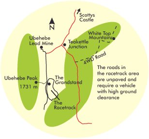
Racetrack Valley is in the middle of nowhere, 56 km (35 mi) west of Scottys Castle, reached by 43 km (27 mi) of dusty road that requires a lot of ground clearance. At its northern end, you first reach the large quartz monolith, The Grandstand, from which a half-hour walk will take you to good pictures of the racetrack farther south. A longer hike takes you over 4,8 km (3 mi) west to Ubehebe Peak, but is somewhat strenuous due to the elevation gain of around 550 m (1800 ft). The main attraction of the valley is The Racetrack, 3,2 km (2 mi) farther south. That spot in the southeast corner of the plain where boulders that have been loosened from the higher elevations due to erosion mysteriously move across the clayey bottom of the dried lake. The current theory is that a rare combination of about 1 cm (0.4 in) of rain wetting the clay and strong winds on the order of 80 km/h (50 mi/h) creates the conditions for this movement. But maybe it’s just the frogs or aliens trying to give us proof of their existence here after all! – Either way, you need the shadows cast by the low sun in the morning or late afternoon and the great depth of field of a short wide angle lens to help the rocks and their tracks in the clay achieve decent depth.
Previous Photo Tips Death Valley NP
Next Photo Tips Death Valley NP – Motifs around Stovepipe Wells Village and the dune fields
Next Photo Tips Death Valley NP – Motifs on Emigrant Canyon Road and around Panamint Springs
If you found this post useful and want to support the continuation of my writing without intrusive advertising, please consider supporting. Your assistance goes towards helping make the content on this website even better. If you’d like to make a one-time ‘tip’ and buy me a coffee, I have a Ko-Fi page. Your support means a lot. Thank you!
 Since I started my first website in the year 2000, I’ve written and published ten books in the German language about photographing the amazing natural wonders of the American West, the details of our visual perception and its photography-related counterparts, and tried to shed some light on the immaterial concepts of quantum and chaos. Now all this material becomes freely accessible on this dedicated English website. I hope many of you find answers and inspiration there. My books are on