

- Altitude between 1700 m and 2100 m (5,577 ft – 6,889 ft)
- About 800,000 visitors per year
- Main visiting month is May
How, Where, What
Deep green valleys surrounded by towering red rock faces. – When the haze of the light spring rain disappears, one imagines oneself in a paradise of boundlessly intense colors.
Canyon de Chelly is the monument whose name no one really knows how to pronounce: „de Schelly„? or „de Schehiji„? The term is a Spanish variation of the Indian „tsegi“ and means something like „stony valley„, the Navajo call it „d`Shay„. However, its significance extends beyond its name, as the National Park Service is solely responsible for its maintenance. However, ownership of the land itself has always been in the hands of the Navajos, who inhabit and work it and to whom it is sacred. Therefore, without Indian guidance, one cannot enter the valley floor.
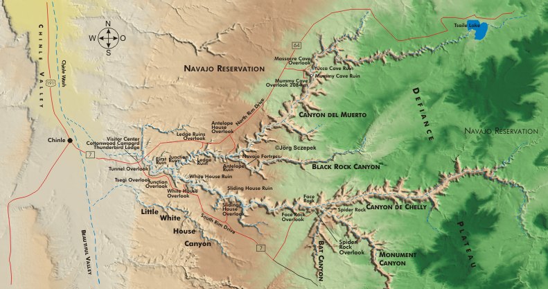
Canyon de Chelly, the main canyon of the monument, extends with its various side valleys for about 43 km (27 mi) from west to east. At its western end, Canyon del Muerto spreads out in a V-shape for about 29 km (18 mi) to the northeast.
The rivers originating in the Chuska Mountains to the east created this truly fascinating canyon landscape. And especially Tsaile Creek and Wiskey Creek continue their work, submerging the canyons well into the spring and thus carving the valley floor deeper. During the monsoon months of July and August, the water masses from the violent thunderstorms often fill the creek channels, making it difficult for even any four-wheel-drive vehicle to advance along the valley floor.
Particularly impressive is the sophisticated architecture of the very well preserved Indian cliff dwellings from the Anasazi period. Built at varying heights on ledges on the canyon walls, they cleverly catch the light of the low sun during the winter. However, shady overhangs always shield them from the summer sun’s power.
Directions
The park is just a stone’s throw east of Chinle. The North Rim Drive (Rt-7) runs along Canyon del Muerto, and the South Rim Drive (Rt-64) runs along Canyon de Chelly. At the intersection of the two Rim Drives is the visitor center. All access into the canyons, except for these two scenic drives and the short hike to White House Ruin, requires a Navajo guide.
Overnight camping is available at the free Cottonwood Campground at the visitor center (no hook-ups for RVs, first come-first served) and at a handful of hotels in Chinle. You can only camp in the backcountry with a Navajo guide accompanying you.
If you don’t have a chance to weave the Coral Pink Sand Dunes in Utah into your itinerary, you can make up for it here. Just under a mile south of Thunderbird Lodge is an extensive field of just such pink dunes. They are so conveniently located that you can shoot them equally well at sunrise or sunset. The unpaved road that branches off to the east at Thunderbird Lodge leads to the dune field. After 2,4 km (1.5 mi) turn right onto a dirt road that ends at the edge of the dune field.
Geographical orientation and the most photogenic times of day
The South Rim is the most photographically rewarding because the viewpoints here almost all face north, allowing you to work with the sun throughout the day. On North Rim Drive, most views face east or southeast, and only a narrow window of time between midday and early afternoon catches light on the ruins on the other side of the canyon. Late afternoon is problematic at many locations due to the heavy shadows cast by the canyon walls.
Canyon de Chelly in the seasons
Due to the altitude of the park area, spring is cool and windy, and dust storms are frequent. Daytime temperatures range from 10°-21° C (50-70 °F), but can go as low as 0° C (32 °F). The summer months are hot, with daytime temperatures ranging from 30°-38° C (86-100 °F). Only rarely does the thermometer drop to a more comfortable 20° C (68 °F). It is very dry. In the fall, it rarely gets cooler than 15° C (59 °F) during the day. You normally encounter easily tolerable values about 20° C (70 °F). Thunderstorms are frequent. Winter is cold and windy. Only rarely does it warm up to 15° C (59 °F). The rule is temperatures between -6° and 4° C (21 and 40 °F). Snowfall is 2-10 cm (0.8-4 in). The weather can change quickly in any season.
Motifs along the South Rim Drive / Canyon de Chelly
Tsegi Overlook, 133 m (436 ft) above the canyon floor, is the first viewpoint on the 48 km (30 mi) long South Rim Drive and offers views of the clayey Chinle Wash and surrounding Navajo farms and cottonwoods that contrast well with the brown earth and dark water.
Across from Junction Overlook and marked by a sandstone monolith, Canyon del Muerto joins Canyon de Chelly. On the opposite side of the canyon is First Ruin.
White House Ruin is the most famous complex of buildings in the canyon. From the viewpoint (located 180 m / 590 ft above the canyon floor) on Rim Drive, the ruins can be seen in their rocky niche. A telephoto focal length of around 200 mm will get them full-frame. Best in the late afternoon, when they are spoiled by the warm light. Even more impressive pictures are taken from the river. Fortunately, the 2 km (1.2 mi) trail (130 m /426 ft elevation gain, 2 hrs round trip over steep switchbacks) is open to visitors. On the other side of Chinle Wash, the house built into the cliff edge is about 15 m (50 ft) above the ground. With a medium telephoto focal length, you can resolve details from the old buildings from the fenced-off smaller side complex. Grazing light from the side highlights both buildings, which face primarily south. However, afternoon sun to the southwest or west is even better than morning light, which is shadowed many times by the course of the canyon. Ansel Adams truly immortalized White House Ruin for all photographers in the 1930s with his famous B&W image: from a knoll on the opposite side, he chose a perspective without the lower buildings, emphasizing the location below the towering cliff face – no problem duplicating this view today and bringing out the details in the dessert varnish along the cliff face above the ruins.
However, the view across Chinle Wash also presents a compelling image: on clear evenings, the setting sun illuminates the red canyon walls, and if the creek has sufficient water, it reflects these walls.
After traveling 10 km (6 mi) further on South Rim Drive, a short spur road leads to Sliding Rock Overlook. Directly across from it, on a narrow ledge, is Sliding House Ruin.
At mile 14.5 from the visitor center is Wild Cherry Overlook above the canyon of the same name. A turnoff leads to Spider Rock Overlook (330 m / 1,082 ft) at the end of the overlook road. Spider Rock, 270 m (885 ft) high, marks the confluence of Canyon de Chelly and Monument Canyon. A short trail takes you to several overlooks with changing views. At midday, a shadowless blue illuminates the entire valley. It gets more dramatic in the afternoon, when the black shadows of the western canyon walls enliven the picture. The best time to take pictures is just before they engulf the slender rock needle.
Motifs along the North Rim Drive / Canyon del Muerto
North Rim Drive leads 28 km (17.5 mi) to four overlooks. 8 km (5 mi) past the Rio de Chelly Bridge, you reach Ledge Ruins Overlook. A trail leads south a short distance to the Dekaa Kiva Viewpoint, overlooking the ruins of the same name.
Quasi opposite, separated by a small side canyon, is Antelope House Overlook, reached by another spur road. At this point, Canyon del Muerto and Black Rock Canyon join. Antelope House is the second-largest ruin in the monument. The sun only reaches its remains at midday. A true wide angle of around 24 mm is needed to capture the Navajo Fortress complex along with the two river branches surrounding it.
The last two viewpoints to the north, 24 km (15 mi) away, are Mummy Cave and Massacre Cave. If you want to capture the best light on the Mummy Cave Ruin, the largest complex of buildings, it’s best to finish the North Rim Drive here early in the afternoon, no later than 16:30.
A trip to Canyon del Muerto, on horseback or by jeep, is worthwhile, especially for the exceptionally well-preserved petroglyphs. Right at its mouth in Canyon de Chelly, there are some wonderful depictions of Kokopeli, the flute player. You can best see the petroglyphs and carvings to the left of Antelope Ruin from the valley floor around noon. Near the Standing Cow Ruin, the rock immortalizes about 20 Spaniards on horseback, serving as a reminder that the Native Americans used the canyons as a hiding place from foreign conquerors. Unfortunately, a fence separates us from them by about 30 m (100 ft), necessitating the use of a telephoto lens with a focal length of more than 300 mm.
Motifs in the Canyons
Between June and September, you can join individual and group tours into the canyons led by Navajo guides. The half-day tours generally go to White House Ruin in Canyon de Chelly and Antelope House Ruin in Canyon del Muerto. Additionally, the full-day tours offer access to Spider Rock and Mummy Cave. However, everything depends on the weather conditions and the passability of the 4WD track in the canyons. Note that these group events make only short stops, which means that the opportunities for the demanding photographer are limited. Individual tours are much better, but also more expensive. Guided tours in a rented SUV cost a good $180 for 1-3 people and 3 hours, with each additional hour costing about $50. For tours in your own SUV, the hourly rate is a good $40. For guided hikes, Navajo guides charge from $30 per hour (1-15 people). While you can easily cover most of the subjects in Canyon de Chelly from the Rim Drive, a guided hike in Canyon del Muerto is more appealing due to its greater number of petroglyphs. Many Navajo guides now offer their services on the web, and, at least during the peak travel season, you would do well to make reservations in advance this way.
Often, one must cross private land to access the partially hidden petroglyphs. This requires advance permission from the owners at the visitor center. However, even if you manage to secure permission, capturing high-quality photos remains challenging due to numerous additional restrictions. For instance, you cannot enter farmland, nor can you climb the rocks to reach the drawings. For these reasons, it is recommended that you carry long focal lengths of 300 mm or more during your tours and a tripod. One of the outstanding rock art panels where all these regulations apply is the spectacular Narbona Expedition Panel near Standing Cow Ruin. On the other hand, Blue Bull, located in Canyon del Muerto, boasts equally beautiful drawings and is easily photographable.
Minimum program and daily schedule
One afternoon is enough to capture at least a few of the numerous subjects along the South Rim Drive that require this fine light. Within 1 ½ days, you can first explore the two Rim Drives at leisure, followed by a trip into either Canyon de Chelly or Canyon del Muerto.
If you found this post useful and want to support the continuation of my writing without intrusive advertising, please consider supporting. Your assistance goes towards helping make the content on this website even better. If you’d like to make a one-time ‘tip’ and buy me a coffee, I have a Ko-Fi page. Your support means a lot. Thank you!
 Since I started my first website in the year 2000, I’ve written and published ten books in the German language about photographing the amazing natural wonders of the American West, the details of our visual perception and its photography-related counterparts, and tried to shed some light on the immaterial concepts of quantum and chaos. Now all this material becomes freely accessible on this dedicated English website. I hope many of you find answers and inspiration there. My books are on