

„…I started my work again! – and in the most exciting environs, – the Big Sur. … The coast was on a grand scale: mountainous cliffs thrust buttresses far out into the ocean, anchored safely for an eternity: against the rising sun, their black solidity accentuated by rising mists, and sunlit water. … My desert rocks were much easier to work with, and quite as amazing, or more so. They were physically approachable, I could walk to their very base , touch them. At Big Sur, one dealt with matter from hundreds of feet to many miles distant. The way will come in time to see this marriage of ocean and rock. …“
Edward Weston, Daybooks March 2nd, 1929
How, Where, What
Weston’s quotation probably best expresses what Big Sur is about: nature, the scale of which eludes man and therefore denies itself to him. It is too powerful, overwhelming, and beyond our comprehension. Only in time, says Weston, can we comprehend this connection between rock and ocean. A fleeting glance is enough to physically grasp that denial: The impressive range of the Santa Lucia Mountains moves so close to the ocean that neither path nor walkway remains between the two elements for us fragile creatures. It seems as if the forces had conspired against us, as if they wanted to keep a secret here forever. In view of this, humility is the only appropriate feeling, because without aid, on our own, we are lost here.
Humility, or at least respect, is what people have always shown this land. El Sur Grande, „the far south“, is what the Spaniards called the inaccessible area south of Monterey. Hardly a foot’s breadth of space was left for exploration. Even the hardy lumberjacks did not advance here until the end of the 19th century in search of potent redwoods and founded the first settlements. The term Big Sur, which is commonly used today, probably dates from this time. With the closing of the gap in Highway No. 1 in the 1920s, the area slowly caught up with the rest of California and soon attracted a colorful mix of artists and writers. True avantgardists, for whom seclusion was an early inspiration. This feeling has been preserved to this day, too, or perhaps especially, because Big Sur has steadfastly refused to join the ranks of the National Parks.
It is estimated that about 6 million people visit Big Sur each year.
Directions
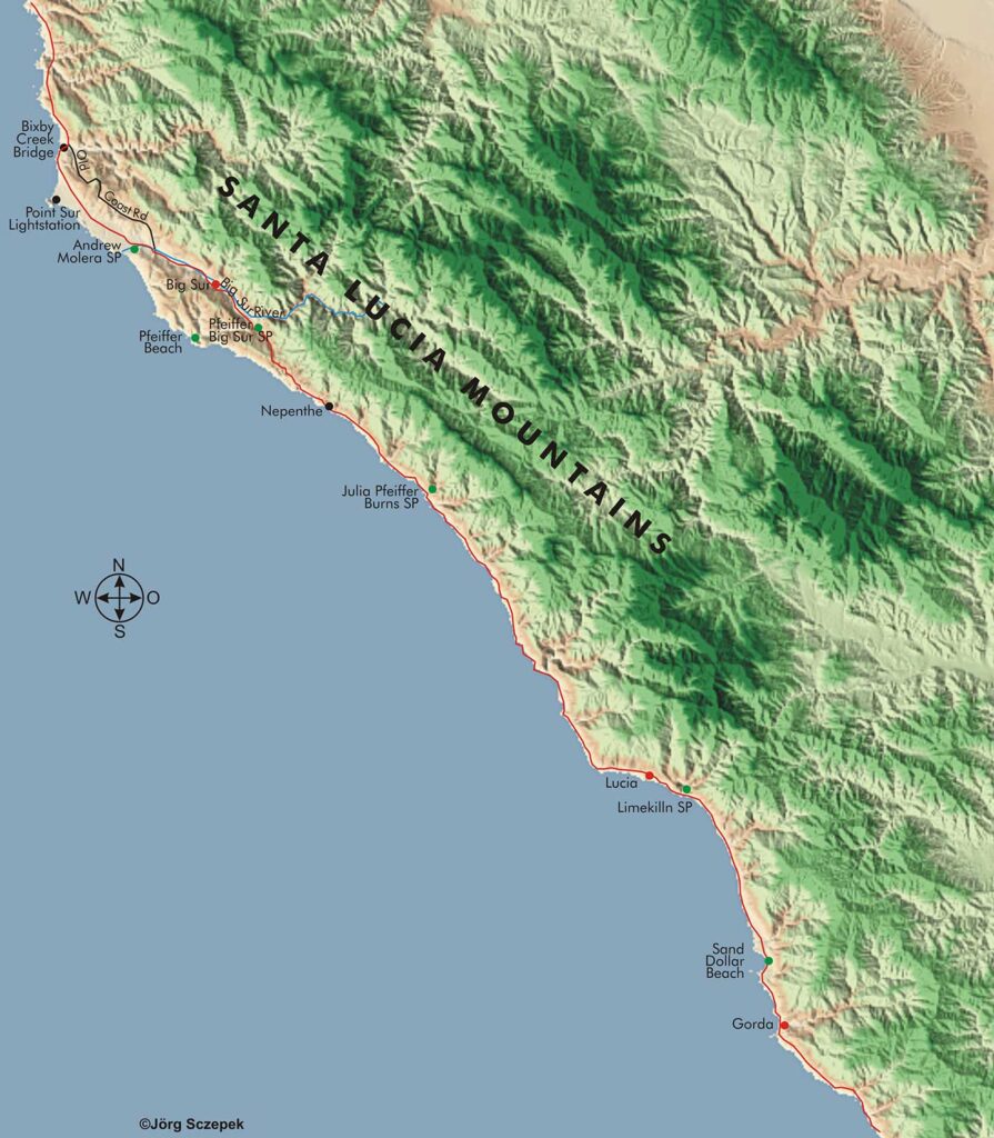
So Big Sur is not a place or delineated protected area in the sense of a state or national park. It is the designation of the stretch of coast between Point Lobos and San Simeon. For our purposes here, let’s define Big Sur as the area between Bixby Bridge to the north and Ragged Point to the south. This is a good 90 highway miles (145 km). Route 1 (aka Cabrillo Highway) is the only connection for modern traffic. On foot, on the other hand, one could take advantage of the many hiking trails in the Santa Lucia Mountains.
Tourist facilities, lodging, and utilities are found primarily in two clusters along Route 1. The Big Sur River Valley area around the tiny town of Big Sur is the northernmost and largest. There, the only visitor center is a joint venture of the State Park Service, the U.S. Forest Service, and the California Department of Transportation. Hotels include the Big Sur River Inn, Driftwood and Sandpiper Cabins, Glen Oaks Motel, Ripplewood Resort, and Fernwood Resort. Campers can stay at the Big Sur Campground or the Fernwood Resort. In addition, there are a couple of restaurants. The Big Sur River Inn General Store sells daily necessities. The second cluster is located around Restaurant Nepenthe, a little farther south, and includes hotels such as Feast for the Senses Vacation Retreat, Post Ranch Inn, Ventana Inn & Spa (which also provides a campground), and Deetjen’s Big Sur Inn. Moreover, the following state parks provide noteworthy tourist facilities. Andrew Molera SP (campground, first come – first served), Pfeiffer Big Sur SP (campground, also sites for RVs), Julia Pfeiffer Burns SP (campground, no RVs), Limekilln SP (campground, also RV sites), Plaskett Creek Campground in Los Padres National Forest (campground, also RV sites). So options are limited, and if you are planning an extended stay in Big Sur, you should pre-book your lodging option.
Geographical orientation and the most photogenic times of day
Big Sur is a destination for the second half of the day, as the high mountain ranges on the east side shield the coastline from the morning sun for an extended period, while the ocean on the west welcomes the warm light of the low afternoon sun. In addition, especially in the summer months, dense fog tends to lie over the landscape until at least midday, which, although it also visually separates the cliffs, makes wide landscape shots impossible. You should therefore spend the morning away from the coast in the hinterland, where beautiful, detailed studies await your macro lens under these conditions.
Motifs along Highway No 1
The 80 m (262 ft) high and 218 m (715 ft) long Bixby Creek Bridge (formerly known as Bixby’s Bridge, Mill Creek Bridge, or Rainbow Bridge) 34 km (21 mi) south of Carmel is one of the landmarks of Big Sur. It opened in 1932 and granted automobile traffic access to this wild stretch of land for the first time. Prior to that, travelers had to take long detours through the backcountry, so the 48 km (30 mi) round trip between Monterey and the Big Sur River Valley took a full three days.
Near the bridge, Route 1 runs almost at sea level, offering good opportunities to get a nice close-up view of the rock outcroppings jutting out of the water near the shore. Just before the north end of the bridge, a gravel road branches off to the east. Following it up the first hill will provide a nice view of the bridge in front of the ocean. The parking bays at either end allow the massive support pylons and the wide concrete span of the structure to be dramatically close in the picture using a decently short wide-angle lens. The fog, common on summer days, is a gift here, as it lends a mystical feel to the bridge seemingly coming out of nowhere. A good mile south of the bridge follows a turnout, which provides the classic image of the bridge in the distance and the steep, rugged coastal landscape in front of it. A 50 mm focal length and a horizon line that’s not too low help these striking elements come into their own.
With half a day to spare, you can continue through the gravel road mentioned at the beginning (Old Coast Road). It takes you away from the coast into the densely forested hinterland and eventually rejoins Rt-1 at Andrew Molera SP. This way, you will also get to know this other side of Big Sur. However, you’ll need a vehicle with high clearance and/or four-wheel drive to tackle it.
Point Sur Lighthouse sits on a 110 m (360 ft) high volcanic cliff just offshore. Commissioned in 1889, the lighthouse continues to guide shipping along the dangerous California coastline. Three-hour guided tours explore the grounds of Point Sur Lightstation State Historic Park on Wednesdays and weekends. Because the coastline forms a far-forward nose at this point, you can get a good overall view of the tower on its rocky ridge from many points along Rt-1 north and south. But even better is the view from there back in both directions, where you can place the sometimes rugged, sometimes sandy coastline in front of the all-towering Santa Lucia Mountains. You won’t find many opportunities to do this. If you are particularly ambitious, you can make the lighthouse into a very special image: Before nightfall, find a shooting position from which you have the coastline, the surf, and, especially important, the beacon in your viewfinder. To ensure that the light in the picture is not too small, the focal length should not be less than 80 mm. Then wait until the sun has set, but the contours are still clearly visible against the hopefully fog-free, dark blue sky. Determine the exposure and regulate it down to at least 8 minutes by stopping down and possibly using a gray filter (-2 EV or similar). To prevent vibrations, close the viewfinder and release the shutter using either a cable release or a self-timer. The camera is securely on the tripod, of course. In this manner, the long exposure time captures the surf as a gentle white veil, while the small aperture sharply highlights the beacon as a jagged star. To prevent it from being hopelessly overexposed, briefly cover the lens with your hand after half the exposure time when it appears in the image in its orbit.
After passing Point Sur Lighthouse, Rt-1 swings in a slight arc away from the coast and reaches Andrew Molera State Park 34 km (21 mi) south of Carmel. This is the largest protected area in Big Sur. The park is open from a half hour before sunrise to a half hour after sunset and offers more than 30 km (18 mi) of designated hiking trails in an otherwise undeveloped area. Therefore, you’ll get a good sense of the Big Sur ecosystem, which includes the coast with its lagoons and sandy beaches, the rivers that originate in the Santa Lucia Mountains, vast meadows, and oak woodlands. Two trails are particularly recommended. The Ridge Trail is a steep path that climbs the hills up to 300 meters (980 ft) high, from where you can enjoy spectacular views of the coast. From up there, you have the best opportunities to take panoramas of the coast and hinterland in the light of the low afternoon sun. If you have limited time for Big Sur, spend it here. A trail combination brings you to the coast and Big Sur’s longest beach via the Beach Trail along the south side of the Big Sur River. There, the Headlands Trail connects. It leads through an eucalyptus grove to a high point overlooking the Big Sur River and a sandy beach. This is a very good location for a sunset. Back to the parking area, you can take the Creamery Meadow Trail, which roams inland in an arc farther from the river.
Beyond Andrew Molera SP, the Big Sur River empties into the Pacific Ocean. Upstream, inland, it flows through an elongated valley named for it. Big Sur, the only village-like collection of houses in this area, sits in the middle. Otherwise, there are only widely scattered ranches here.
At Pfeiffer Big Sur State Park (42 km / 26 mi south of Carmel), the Big Sur River runs through a 3 km2 (740 ac) area of redwoods, maples, and sycamores. This park is also open from a half hour before sunrise to a half hour after sunset. There is a small store for daily necessities and similar amenities. Campsites can and should be reserved at https://www.parks.ca.gov/. Especially during the summer months, although it is 5 mi from the ocean, there is no other option to stay here, and you may have to travel dozens of miles further south. The exclusive Big Sur Lodge is also located here in the state park, making it the perfect base to explore Big Sur. In the park itself, one of the main attractions is Pfeiffer Falls, which plunges 12 m (40 ft) into a small grotto. They are reached via the Pfeiffer Falls Trail and the Valley View Trail, together 3,2 km (2 mi) long with a 60 m (197 ft) elevation gain. The trail passes under stately redwoods and along Pfeiffer-Redwood Creek. At the end, you will reach a viewing platform at the base of the waterfall, which is at its most beautiful after decent rains, as the creek that feeds it has a small catchment area. Therefore, the months between December and May are the best. Because of its westward orientation, this subject needs the light of the afternoon sun for proper illumination. A 28 mm wide angle lens is the optic of choice to image the waterfall along with its surroundings. On the way back along the Valley View Trail, you will pass a higher vantage point that looks out over the Big Sur River Valley to the coast. This is a late afternoon shooting location when the low sun bathes the landscape in warm golden light. So it fits well as a connection to Pfeiffer Falls.
In the Big Sur River area, you can record groups of southbound monarch butterflies during the winter months between November and March. At temperatures below 13° C (55 °F), they can no longer fly and gather, resembling large clumps, against trees to provide warmth for each other with outstretched wings. Since they often hang several feet above the ground, you’ll need at least 200 mm of focal length and a powerful flash to get full-frame portraits.
One mile south of the state park entrance, take the hidden Sycamore Canyon Road (the 2nd side road on the right heading south) to Pfeiffer Beach, one of the jewels of the area. Pay close attention because there is a road sign but no indication of the beach. The road is narrow and steep and should not be traveled by large RVs. The last stretch is a footpath through a grove full of wonderfully wind-deformed Monterey Cypress trees. The beach is accessible between 09:00 and 20:00, and you have to pay an entrance fee, but this easily makes up for the scenic beauty. The beach forms a fine sandy semicircle between rolling hills to the north and south, with mighty rock pinnacles a few meters out in the water where the incoming waves break. With a long focal length and decently fast continuous shooting, you can capture sequences of the swirling spray and certainly have some good frames. One of the monoliths, Arch Rock, has a natural opening where you can frame the setting sun. To do this, orient your exposure to a piece of sky next to the sun to get the right silhouette effect. The south end of the small bay is particularly rocky, making it the perfect backdrop for the sunset. After heavy rains, however, Pfeiffer Creek, which empties there, can carry so much water that you’ll have to wade through it.
The common place name Pfeiffer in Big Sur goes back to Michael and Barbara Pfeiffer, who were the first European settlers to come to this coastal strip in 1869.
The Nepenthe has been an institution on this coast since 1949. Perched nearly 300 m (984 ft) up on a jutting cliff, this restaurant/café/craft store offers a spectacular panoramic view of the coastline. The terrace is a wonderful place to relax, look around and take photos, especially in the mornings and afternoons.
In the miles between Nepenthe and Julia Pfeiffer Burns State Parks, spectacular views of the series of far-jutting cliffs of the Santa Lucia Mountains are available from many park bays along the road. At midday, the ghostly cliffs rise from the often-appearing shallow fog banks, creating striking back-to-back silhouettes. In the late afternoon and at sunset, they glow in the vivid red of the low sun, providing a perfect backdrop for the ocean movements captured with long exposures.
Julia Pfeiffer Burns State Park is 6 km (37 mi) south of Carmel, just off Highway 1. It, too, is open from a half hour before sunrise to a half hour after sunset and offers some basic campsites, restrooms, hiking trails and picnic areas. Here, too, you can hike through redwood and oak groves hundreds of feet up into the mountains. But the main attraction is the beautiful 25 m (82 ft) high McWay Cove Waterfall, one of the few waterfalls that flow directly into the ocean. You can reach it via the hiking trail of the same name in the parking lot of the SP. This is an easy trail, only a little more than 1 km (0,6 mi) long, that first leads through a tunnel under the highway and then along the eucalyptus-covered McWay Creek to an elevated viewpoint above McWay Cove. From there, you’ll look directly down on the semi-circular, small sandy beach, framed by rock cliffs on the north and south sides. That´s a beautiful shot, and you don´t want to miss it! At its south end, the waterfall gushes out from between the rocks. At low tide, it pours onto the beach, and this is the perfect image when the sun is low in the western sky around 17:00, bathing the scene in golden light. Check with the rangers beforehand for tide times or consult the El Sur Grande newspaper, which is available free of charge. To get a full-frame image of the waterfall, you’ll need a telephoto focal length of at least 120 mm. The overall view calls for a 24 mm wide angle. Include some of the reeds growing along the trail to help give it greater depth. On an overcast or foggy day, it is worth following the trail further into the dense redwood stand. Then conditions are good for wringing a few motion studies out of McWay Creek with long exposures. In addition, the park is a very good location to observe the passing gray whales. In December and January, they migrate south to their wintering grounds off Baja California, and in March and April, they pass through this area again on their way to their summer feeding grounds in the North Pacific. They come particularly close to the coast here (up to 1 km / 0.6 mi) and now and then even one of the mighty mammals swims into the bay. The Overlook Trail leads to a well-situated vantage point from which you can capture these spectacles with a long focal length.
Just 320 m (0.2 mi) past the entrance to Julia Pfeiffer Burns SP, there’s a small parking bay (the second one) on the right in the southbound direction, offering excellent views of the shoreline, the jutting cliffs, and the prominent rocks just offshore (in the northbound direction, at the „SP 1/4 mi“ sign).
Near the south end of the stretch of coastline known as Big Sur at Ragged Point, another highlight is found 88 km (55 mi) south of Carmel at Sand Dollar Beach. This is Big Sur’s longest and most beautiful sandy beach, shaped like a perfect crescent moon, with prominent rock pinnacles in front of the shore that create a perfect sunset foreground. Sand Dollar Beach is a so-called day use area and is open from 09:00-20:00. You have to pay an entrance fee. Nearby is the Plaskett Creek Campground, where you can spend the night with your tent or camper.
Minimum program and daily schedule
Spend at least one afternoon in one of the state parks along Route 1 to capture the best light of Big Sur. This is easiest to arrange if you drive the route from south to north and Carmel or Monterey is your stage destination. The other way around, you won’t enjoy driving much farther than San Luis Obispo in the dark. If you have more time, it’s a good idea to stay in the Big Sur River Valley, exploring the backcountry on one day and the coast on at least another.
If you found this post useful and want to support the continuation of my writing without intrusive advertising, please consider supporting. Your assistance goes towards helping make the content on this website even better. If you’d like to make a one-time ‘tip’ and buy me a coffee, I have a Ko-Fi page. Your support means a lot. Thank you!
 Since I started my first website in the year 2000, I’ve written and published ten books in the German language about photographing the amazing natural wonders of the American West, the details of our visual perception and its photography-related counterparts, and tried to shed some light on the immaterial concepts of quantum and chaos. Now all this material becomes freely accessible on this dedicated English website. I hope many of you find answers and inspiration there. My books are on