

„Noble sheet of blue water lifted 6,300 feet above the level of the sea and walled in by a rim of snow-clad mountain peaks…“
Mark Twain
How, Where, What
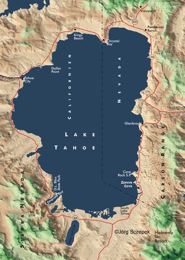
Due to its size of 35 x 20 km / 22 x 12 mi, Lake Tahoe is known as the most remarkable lake in the Sierra Nevada, as its size allows for diversity. Along its 115 km (71 mi) of shoreline, you’ll find bustling tourist towns, sophisticated mansion quarters, the quiet beaches of four state parks, and ski slopes that are among the best in the country. All set against a proverbial blue-water backdrop.
Directions
Lake Tahoe’s area is divided 2/3 to 1/3 between the states of California and Nevada. Rt-89, Rt-28 and Rt-50 circle it clockwise from the south, taking you through Tahoe City, the center on the California side to the northwest, and South Lake Tahoe, the Nevada counterpart in the southeast corner. During the summer months and ski season, pre-book your lodging options in the main towns due to crowds.
Motifs around Lake Tahoe
Due to the unfortunately dense development in many places and the fortunately dense forestation elsewhere, there are only a few points for long-range overview shots. The tour described below circles the lake against the direction of the light but puts you in a good shooting position at the right time at two important points.
On a clockwise round trip from the south, you first pass Inspiration Point on the south side of Emerald Bay. From here, you look across the bay of the same name and the tiny granite mountain of Fanette Island, the only island in the lake, to the mountains of the Desolation Wilderness from a sufficient height. Over the next mile, Rt-89 climbs a little further, and a small overlook soon gives a view right across the middle of Emerald Bay to Spooner Summit on the Nevada side. This is probably the most famous image of Lake Tahoe, as its deep blue waters dominate the foreground. Once again, the road crosses Eagle Creek just a short distance away, and a short walk from there leads to the breathtaking Eagle Falls. The water here pours into Emerald Bay over three tiers, and during the snowmelt from spring to early summer, this is at its most spectacular. The very best time to take in the top tier is at sunrise. Then you can wait for the exact moment when the first rays of the sun, rising just opposite, turn the foaming tide into a ribbon of pure gold. An exposure time in the range of 1/15 sec or less provides pleasant motion blur. Directly below and only accessible via a rather steep footpath is Vikingsholm, a replica of a Viking castle. Between June and September, you can visit it and enjoy the beautiful view over the lake. Leaving Emerald Bay behind, you can reach the beautiful beaches of Bliss Beach and Rubicon Point by vehicle at D.L. Bliss State Park, again not far away on the east side of Lake Tahoe. Here, you can visit an old wooden lighthouse and climb around in remarkable rock formations. The rest of the way north from Tahoe City is via Rt-28, and in town, it’s worth branching off to Dollar Point on the advanced headland. Once you reach the northern end of the lake at Crystal Bay, it is well worth taking a short detour onto Rt-431. From the parking lot, 4.8 km (3 mi) past the junction, you’ll have the best morning view of the entire length of the lake and the Sierra peaks in the background. Back on Rt-28, after a few miles you will reach Ponderosa Ranch, the filming location of the well-known series Bonanza. Between April and October, you can visit the set. If you arrive here by midday, you will still have enough time afterwards to while away the early afternoon on the beach at Lake Tahoe Nevada State Park and still get to the Cave Rock and Zephyr Cove areas in time for sunset. Both locations are well-suited for setting the water’s edge, punctuated by photogenic rocks, against the backdrop of the Sierra, still overhung by a fiery red evening sky. Beyond that, it’s only a few miles back to South Lake Tahoe, the trailhead. If you don’t feel like driving during your stay, a streetcar ride up to Heavenly Ski Area 600 m (2,000 ft) above South Lake Tahoe is recommended – the early morning view of the Sierra peaks to the northwest is truly spectacular!
Previous Photo Tips Bodie Ghost Town
Main Photo Tips USA – California
If you found this post useful and want to support the continuation of my writing without intrusive advertising, please consider supporting. Your assistance goes towards helping make the content on this website even better. If you’d like to make a one-time ‘tip’ and buy me a coffee, I have a Ko-Fi page. Your support means a lot. Thank you!
 Since I started my first website in the year 2000, I’ve written and published ten books in the German language about photographing the amazing natural wonders of the American West, the details of our visual perception and its photography-related counterparts, and tried to shed some light on the immaterial concepts of quantum and chaos. Now all this material becomes freely accessible on this dedicated English website. I hope many of you find answers and inspiration there. My books are on