

Red Rock Canyon NCA is located 32 km (20 mi) west of Las Vegas on Rt-159, this is effectively the extension of West Charleston Boulevard, which branches off Las Vegas Boulevard. The lovely serenity and wonderful red sandstone formations, which contrast well with the gray limestone of the Wilson Cliffs in the background, attract those who are tired of the hustle and bustle of the Strip. These views alternate with the yuccas and Joshua trees typical of the Mojave Desert.
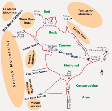
Because of its location to the west, you should begin the roundtrip via Rt- 159 and Rt-160 early in the morning. This is when the Calico Hills glow in the light of the sun low in the east, and the contrast with the less colorful limestone formations is greatest. You should allow at least 3 hours for the trip from Las Vegas.
Once you leave behind the last houses on West Charleston Boulevard and reach a small hill, you can enjoy an elevated view that spans the entire length of the Las Vegas Boulevard high-rise complexes. A focal length of 200-300 mm is ideal for capturing details, while 50-80 mm provides an impressive overview.
A few miles down the road, make a right turn onto the 20 km (13 mi) Scenic Drive, which traverses the Red Rock Canyon Conservation Area as a one-way road. It is open to visitors as follows: November through February: 06:00 – 17:00, March: 07:00 – 17:00, April – September: 06:00 – 20:00, October: 06:00 – 17:00.
The Red Rock Canyon Overlook off Rt-159 is accessible for one additional hour. It offers a good view of the yellow-red formations of Red Rock Canyon to the north and the high Wilson Cliffs to the west. The visitor center, located just beyond the entrance, is open daily from 08:00 – 16:30. From there, a panoramic view of the Calico Hills to the north is well worth seeing. A short distance along the Loop Road leads to the parking lots known as Calico I and Calico II. From both, you can walk the easy Calico Hills Trail. It leads northwest along Calico Rocks for 1,6 km (1 mi) to the Sandstone Quarry Trailhead and offers interesting views of the rock formations. It also passes by a rock that exhibits intriguing petroglyphs.
4,8 km (3 mi) north of the park entrance is the aforementioned Sandstone Quarry Trailhead on the Scenic Road. Two trails begin there: the Turtlehead Peak Trail, which climbs more than 500 m (1,640 ft) over 4 km (6.5 mi), and the Calico Tanks Trail. The Calico Tanks Trail leads over 2 km (3.2 mi) with little elevation gain through the red sandstone landscape to several natural water reservoirs and offers, from just below the summit of the Calico Hills, a stunning view of the sea of houses of Las Vegas to the east.
I recommend the trails branching off further west from Park Road into Icebox Canyon, Pine Creek Canyon, or Oak Creek Canyon to get closer to the limestone formations of the Spring Mountains. In this area, the terrain is gently rolling with some Joshua trees. Before you reach the junction with Rt-160, you’ll pass Spring Mountain Ranch State Park and Bonnie Springs, an old western town restored for tourists.
Previous Photo Tips Las Vegas – Hoover Dam and Lake Mead
Previous Photo Tips Las Vegas – Motifs on Las Vegas Boulevard
Previous Photo Tips Las Vegas and vicinity
If you found this post useful and want to support the continuation of my writing without intrusive advertising, please consider supporting. Your assistance goes towards helping make the content on this website even better. If you’d like to make a one-time ‘tip’ and buy me a coffee, I have a Ko-Fi page. Your support means a lot. Thank you!
 Since I started my first website in the year 2000, I’ve written and published ten books in the German language about photographing the amazing natural wonders of the American West, the details of our visual perception and its photography-related counterparts, and tried to shed some light on the immaterial concepts of quantum and chaos. Now all this material becomes freely accessible on this dedicated English website. I hope many of you find answers and inspiration there. My books are on