

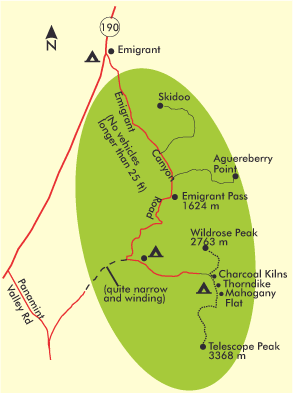
Motifs on Emigrant Canyon Road
For the onward journey westward, the detour via Emigrant Canyon Road is recommended (no vehicles longer than 25 ft). It branches south off Rt-190 13 km (8 mi) west of Stovepipe Wells Village and takes a 48 km (30 mi) loop through the high elevation part of the park in the Panamint Mountains to Rt-178 in the Panamint Valley, with 6,5 km (4 mi) past Wildrose unpaved. From there, you then have another good 24 km (15 mi) to get back to Rt-190. Start at Stovepipe Wells early in the morning to reach the remarkable Aguereberry Point, still in the fine light of the low sun. If you approach the other way around from the west, it is also worth the trip in the late afternoon. 34 km (21 mi) from Stovepipe Wells, a 10 km (6 mi) dust road branches off here to the edge of the plateau to the east. At an elevation of 1961 m (6,400 ft), the view from here runs the length of Death Valley. In the afternoon, the sun in the west highlights the opposite peaks of the Amargosa Range photogenically. 16 km (10 mi) further south, you reach the junction of Charcoal Kilns and Mahogany Flat. At the junction are a ranger station and Wildrose Campground, open year-round. The ten large kilns, where charcoal was made, are another 11 km (7 mi) from here. They are all the same size: about 7 m (23 ft) high and 9 m (29 ft) wide, and they stand in a straight row. If you choose to spend the night at the campsite, you can hike up to the 2763 m (9,064 ft) high Wildrose Peak, which is a 13 km / 8.3 mi round trip, with an elevation gain of 670 m / 2,200 ft. After only 3 km (1.8 mi) you can enjoy beautiful views into the valley through the pine forest. Mahogany Flat, located at the end of a rough dust road, lies 3.2 km (2 mi) further south of Charcoal Kilns. This is the starting point for the Telescope Peak Trail, which also allows good views into Death Valley. Telescope Peak is at 3368 m (11,049 ft) the highest elevation in the park. The 11,2 km (7 mi) long trail can be hiked without problems between May and October, provided you are in good shape to master the 914 m (3,000 ft) gain in altitude. You should calculate 3-4 hours per way. You will be rewarded with a magnificent view that stretches from Mt Whitney in the west to Mt Charleston near Las Vegas in the east, as well as the Bristlecone Pines, ancient pines whose trunks and branches have been twisted by wind and weather into almost unbelievable shapes.
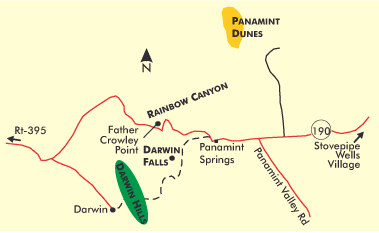
Motifs around Panamint Springs
1,6 km (1 mi) west of the town of Panamint Springs, Darwin Canyon Road branches south off Rt-190. After 4,8 km (3 mi) you will reach a parking area, from which it is only a short walk to the nearly 10 m (32 ft) high Darwin Falls. A waterfall is truly a rarity in this area.
A few miles further west, at the end of the dust road, is the ghost town of Darwin. Its well-preserved remains include the old school building, parts of the mining complex, and various commercial buildings. For a brief period in the 1870s, this site mined various ores and minerals, not silver as was initially believed. This provided for about 200 inhabitants after all. The good accessibility and beautiful location in Darwin Canyon are worth a short visit.
Further east, Rt-190 slowly winds its way back up to elevation, revealing spectacular new views of Death Valley deep to the east after every turn. Father Crowley Point is 13 km (8 mi) beyond Panamint Springs at the end of a short dust road and looks out from an exposed position along the entire length of Rainbow Canyon and onto the Panamint Range. Creosote bushes and low shrubs cover the adjoining landscape, fitting the elevation of about 520 m (1,700 ft). The soil is a striking brown and red color. Upon ascending further, one reaches Lower Centennial Flat, essentially the Inyo Mountains‘ saddle, where a slender stand of Joshua Trees accentuates the limited growth. Not far away, the gray ridges of the Sierra Nevada can already be seen to the west. A good view for the early morning, when the first rays of sunlight make the rocky peaks above the Owens Valley glow red.
Previous Photo Tips Death Valley NP
Previous Photo Tips Death Valley NP – Motifs around Furnace Creek and Scotty`s Castle
Previous Photo Tips Death Valley NP – Motifs around Stovepipe Wells Village and the dune fields
If you found this post useful and want to support the continuation of my writing without intrusive advertising, please consider supporting. Your assistance goes towards helping make the content on this website even better. If you’d like to make a one-time ‘tip’ and buy me a coffee, I have a Ko-Fi page. Your support means a lot. Thank you!
 Since I started my first website in the year 2000, I’ve written and published ten books in the German language about photographing the amazing natural wonders of the American West, the details of our visual perception and its photography-related counterparts, and tried to shed some light on the immaterial concepts of quantum and chaos. Now all this material becomes freely accessible on this dedicated English website. I hope many of you find answers and inspiration there. My books are on