

„Death Valley is very difficult to photograph: A few obvious oppurtunities and a vast number of recalcitrant situations that try the photographer´s patience and craft. Contrary to the universally accepted opinion that Death Valley is good for pictures only in early morning or late afternoon, (Edward) Weston demonstrated that fine images could be made at high noon. …“
Ansel Adams, An Autobiography
- Altitudes between -86 m (-282 ft) at Badwater and 3368 m (11,050 ft) at Telescope Peak
- An average of 1.2 million visitors per year
- The busiest months are November, when the ’49 Encampment takes place, and February-April
How, Where, What
We would still be able to hear the cracking and crashing that began the formation of today’s Death Valley approximately 3 million years ago if we lived long enough and slowly enough. However, because our perception span is too short, we only witness the violent processes in the earth’s interior, such as the displacement of tectonic plates against each other, through the deflections of seismographs.
We have the splitting of the earth’s crust into plates of different sizes to thank for the most diverse geological extremes, and that’s how things are here on the border between Nevada and California. Death Valley’s history is long and varied. Geologists read in it of an ancient lake and of the shifting of two tectonic plates, as a result of which the terrain rose and the water drained away to the west. They date this period of active mountain folding to 250 million years ago. In the course of this process, the earth’s surface became thinner in many places, thin enough to allow lava to escape from the earth’s interior. About 50 million years ago, the volcanic chapter began, and the fire-breathing vents blanketed large parts of the country with thick layers of lava and ash, leaving behind mineral-colored legacies that are still visible today in places like the Artists Palette. Then follows that exciting moment only 3 million years ago, when the tectonic processes reversed, compression turned into expansion, and the extreme case of Death Valley was born. From this point forward, the crust separates into coherent and incoherent parts, as evidenced by the Badwater Basin and the Panamint Mountains in the west. These regions move together towards the east, causing new fractures in the valley’s rock layers that persist to this day. This process even makes up for the effect of erosion, which incessantly fills the valley floor with loose material from the higher regions. In principle, Death Valley is not an unusual landscape in the western United States. Between the coastal mountains of the Sierra Nevada in the west and the Colorado Plateau in the east, countless wave-like ridges rise, separated from each other by plateau-like valleys. It is the same here. However, only this valley is close enough to a tectonic suture to create a depression that features Badwater (-86 m/-282 ft), the lowest point in the Western Hemisphere, in the shadow of Telescope Peak, which is more than 3300 m (11,000 ft) high.
These extremes make for spectacular scenery, such as the varied and multicolored rock formations eroded from the surrounding ridges or the vast expanse of light-colored sand dunes. More than 900 species of plants have adapted to the harsh living conditions in the valley, and the many species of animals, most of whom are nocturnal, give the park ecological importance.
The best time to visit is definitely between November and March, when temperatures reach only 18° to 27° C (64 to 81 °F). During the summer, on the other hand, temperatures can easily reach 45° C (113 °F) and more. This is then too hot for the floral stars of spring, which have names like Brown-Eyed Evening Primrose or Desert Five-Spot. Even in this harsh environment, many wildflower species are reclaiming their habitat with vibrant colors following rainy winters. Flowering begins in mid to late February in the valley areas of Death Valley and the Panamint Valley, progresses through the slightly higher alluvial fans and pass elevations in April (especially Jubilee and Daylight Passes and the Furnace Creek area), and concludes in early June in the 600-1200 m (1,970-3,940 ft) elevations of the Panamints (Telescope Peak Trail is a good site). However, local contact should always precede targeted travel, as many variables influence the wildflower bloom.
Death Valley first gained fame in the second half of the 19th century due to the large borax deposits of the dry, saline lake beds. Even today, the white mineral is an integral part of many industrial processes in the fields of cleaning and glass production. California and the southwestern USA are home to the world’s largest deposits.
Directions
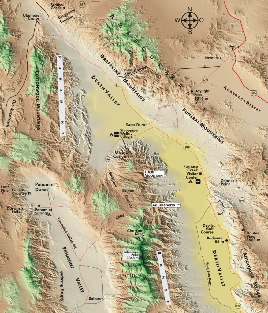
Death Valley National Park is a large protected area, and that brings long distances with it. From Badwater to Scottys Castle, it’s 114 km (71 mi) and from Stove Pipe Wells to the Visitor Center, it’s a 40 min. drive – a long lead time if you want to make it to Zabriskie Point by sunrise. Therefore, a little planning is necessary: If you are traveling to the west from Las Vegas, you should spend one night in the Furnace Creek area to explore Zabriskie Point, Golden Canyon and Badwater. For the second overnight on the way west, Stovepipe Wells Village serves as an excellent starting point for the sand dunes and Mosaic Canyon. Reverse this course as you move eastward toward Las Vegas. Off the main roads (Rt-190, Rt-374 & Rt-267) you will need a high-clearance vehicle or 4WD to get around. Overnight accommodations are available at the following hotels/motels: Furnace Creek Inn at the intersection of Rt-190 & Rt-178, Furnace Creek Ranch a stone’s throw away at the Visitor Center, Stovepipe Wells Village on Rt-190, and Panamint Springs, also on Rt-190, on the eastern border of the park. Campsites are available at the Visitor Center (Texas Spring & Sunset are open October through April, Furnace Creek is available year-round. There are no hook-ups for RVs), at Mesquite Spring near Scottys Castle to the north on Rt-267 (no hook-ups), at Stovepipe Wells Village (hook-ups) and Panamint Springs (hook-ups). During the summer and even in September, you will have little trouble getting a room or a site. For a winter visit, make reservations very early. When embarking on any excursion, ensure you have sufficient water with you and, if required, notify a ranger about your plans for assistance in an emergency. For all vehicles, a full tank of gas and an intact spare tire provide safety in many situations, but are no substitute for caution and information when traveling off-road.
Geographical orientation and the most photogenic times of day
Death Valley National Park stretches for about 210 km (130 mi) parallel to the California-Nevada border from northwest to southeast and includes, in addition to Death Valley itself (located between the 2000 m / 6,560 ft high Amargosa Range to the east and the up to 3000 m / 9,840 ft high Panamint Mountains to the west), a considerable number of side valleys and other ridges. Your best pictures will be taken in the early morning and evening. In the intervening time, the light is too unspectacular for the vast majority of locations. In addition, you can easily observe the fading of distant views as the sun rises higher and higher in the deep valleys of Death Valley. The higher the sun rises, the more it heats up the air masses, which then rise upward, causing the infamous shimmering of the air.
Minimum program and daily schedule
This includes sunrise at Zabriskie Point and the sand dunes, which require a two-day stay. The intervening hours are filled with the Devils Golf Course, Mosaic or Golden Canyon, and a sunset at Dantes View.
Next Photo Tips Death Valley NP – Motifs around Furnace Creek and Scotty`s Castle
Next Photo Tips Death Valley NP – Motifs around Stovepipe Wells Village and the dune fields
Next Photo Tips Death Valley NP – Motifs on Emigrant Canyon Road and around Panamint Springs
If you found this post useful and want to support the continuation of my writing without intrusive advertising, please consider supporting. Your assistance goes towards helping make the content on this website even better. If you’d like to make a one-time ‘tip’ and buy me a coffee, I have a Ko-Fi page. Your support means a lot. Thank you!
 Since I started my first website in the year 2000, I’ve written and published ten books in the German language about photographing the amazing natural wonders of the American West, the details of our visual perception and its photography-related counterparts, and tried to shed some light on the immaterial concepts of quantum and chaos. Now all this material becomes freely accessible on this dedicated English website. I hope many of you find answers and inspiration there. My books are on