

Directions
From Rt-89, first take Rt-89A west and then Rt-67 south in the small village of Jacob Lake. At the beginning of Rt-89A you first cross Marble Canyon, a beautiful motif with the Navajo Bridge in the foreground, and it is a good idea to take the short detour to Lees Ferry, where the canyon and National Park begin. The old Mormon ford is the only place for a long distance to see the canyon from below, from water level, without taking a river trip. There are two large Balanced Rocks located directly on the trail and they are easy to photograph in the afternoon. The Rt-89A continues to climb steadily, and there are beautiful views of the wide plain of the Arizona Strip to the west and the Paria Plateau to the northeast before reaching Jacob Lake in the middle of the Kaibab Forest. It is then 70 km (44 mi) or just under an hour from here via Rt-67 to the North Rim.
Roads and tourist facilities are open to the public only between mid-May and mid-October. After that, there are only day visits available until snowfall eventually isolates this part of the park from the rest of the world.
The only lodging option is the Grand Canyon Lodge with an attached basic campground (no hook-ups for RVs). 8 km (5 mi) north of the park entrance are the Forest Service’s Kaibab Lodge and De Motte Campground on Rt-67, open mid-February to mid-November. Jacob Lake also offers only two campgrounds and a motel as alternatives, and so here too: reserve as early as possible to save yourself a lot of driving.
Motifs on the North Rim
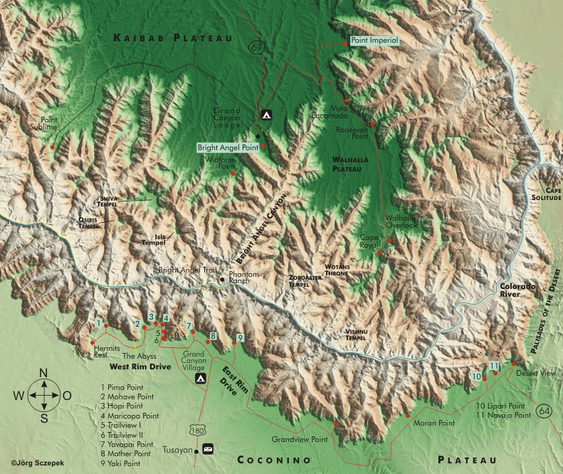
The viewpoints are distributed in a semicircle around the lodge on the ridge of the Kaibab Plateau, projecting to the south.
The westward points of Point Imperial, Vista Encantadora, Painted Dessert Overlook, and Cape Final are naturally suited to watching the sunrise itself, with the canyon still in shadow. Point Sublime is the westernmost and can only be reached via a 27 km (17 mi) dust road (turnoff just south of the entrance station) with an off-road vehicle. Be sure to check the road conditions. The view from there extends much farther into the western part of the canyon than is possible from the south rim.
Of course, sunrise and sunset are the best times to capture impressive pictures, as the sun illuminates the formations from the side, and the shadows it casts add depth to the photographs, allowing one to appreciate the vast dimensions of the canyon.
Bright Angel Point is located near the historic Grand Canyon Lodge with its tourist amenities. Because of its perpendicular position to the canyon, it also calls for directional light in the morning or late afternoon. Directly opposite at a distance of about 15 km (9 mi), you can make out the buildings of Grand Canyon Village on the south rim and, with good visibility, the even more distant symmetrical volcanic cones of the San Francisco Mountains near Flagstaff.
To the east, you’ll first find Point Imperial, at 2934 m (9,626 ft) the highest vantage point above the canyon and the first on the Walhalla Plateau, which reaches far into the canyon. The view from here extends over the Painted Dessert to the east and the dominating formation of Mt. Hayden, which makes a good subject at all times of day, and north to Marble Canyon. Late morning is the best compromise to get meaningful images.
Vista Encantadora, a bit further south, opens up views of the Little Colorado River, which joins its big namesake below Cape Solitude. You should seek it out in the morning as well.
Cape Final can be reached on a 2,4 km (1.5 mi) trail from the parking lot of the same name on Cape Royal Road. The trail and overlook offer spectacular views of the north-south running canyon.
Cape Royal is the final viewpoint at the top of that mighty plateau around which the river winds in a great loop to the west. Below the 400 m (0.3 mi) trail to the lookout is Angel’s Window, a natural rock bridge that is a great way to frame pictures of the river below.
Motifs along the trails
The Transept Trail follows the rim above Transept Canyon for 2,4 km (1.5 mi) from the lodge to the campground. You should allow 2 hours for the walk there and back.
The Ken Patrick Trail begins at the North Kaibab Trailhead Parking Lot and travels through heavily wooded terrain and along the canyon rim for 16 km (10 mi) to Point Imperial.
The Uncle Jim Trail branches off the Ken Patrick Trail and reaches Uncle Jim Point in an 8 km (5 mi) loop overlooking the switchbacks of the North Kaibab Trail.
The Widforss Trail is reached via the dust road to Point Sublime. It leads for 8 km (5 mi), half along the fault line and half through the forest, to Widforss Point. There and back, you should calculate 6 hours.
Cliff Springs Trail (1,6 km / 1 mi there and back) starts opposite the Angels Window Overlook on the road to Cape Royal. Through a wooded canyon and past a small Indian settlement remnant, it leads to the spring, whose water is not drinkable.
The North Kaibab Trail starts 3,2 km (2 mi) north of the lodge and is the only trail on the North Rim that leads down to the Colorado. Through Roaring Springs Canyon and Bright Angel Canyon, it descends 22,5 km (14 mi) and 528 m (1,732 ft) to Phantom Ranch, and only true „iron men and women“ walk it there and back in a day. If you want to spend the night at the river, you have to reserve your place at Phantom Ranch or your backcountry permit as early as possible. For this challenging trail, it’s best to keep your equipment to a minimum: a 24 mm wide angle for dramatic shots and a light telephoto zoom will suffice. You can rest or turn around at the following points: Supai Tunnel (3,2 km / 2 mi, 439 m /1,440 ft difference in elevation), Roaring Springs (this is where the mulicaravans go, 7,6 km / 4.7 mi, 927 m / 3,041 ft difference in elevation), Ribbon Falls (waterfall, 13,5 km / 8.4 mi, 1378 m / 4,520 ft difference in elevation).
Minimum program and daily schedule
North Rim is merely a short distance from its densely populated counterpart, yet it already inhabits a distinct, tranquil realm, brimming with images that haven’t been replicated a thousand times. You should invest a whole day, including an overnight stay, to breathe this unconsumed air.
Previous Photo Tips Grand Canyon NP
Previous Photo Tips Grand Canyon South Rim
Next Photo Tips Toroweap Point
If you found this post useful and want to support the continuation of my writing without intrusive advertising, please consider supporting. Your assistance goes towards helping make the content on this website even better. If you’d like to make a one-time ‘tip’ and buy me a coffee, I have a Ko-Fi page. Your support means a lot. Thank you!
 Since I started my first website in the year 2000, I’ve written and published ten books in the German language about photographing the amazing natural wonders of the American West, the details of our visual perception and its photography-related counterparts, and tried to shed some light on the immaterial concepts of quantum and chaos. Now all this material becomes freely accessible on this dedicated English website. I hope many of you find answers and inspiration there. My books are on