

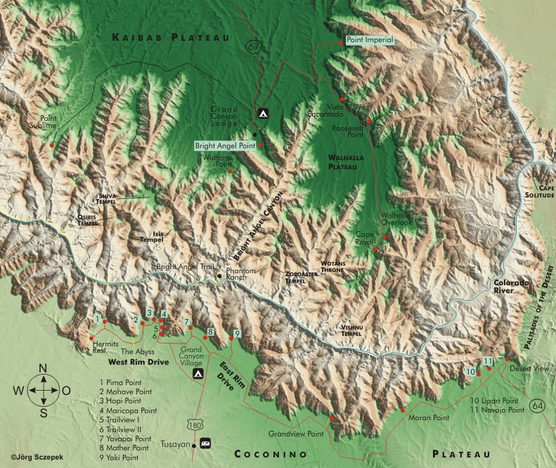
Directions
No matter where you come from, the change of scenery from the plain up to the subalpine pine and spruce forests of the Coconino Plateau is impressive. The south rim is accessible 24 hours a day, every day of the year. If you plan to stay within the park at one of the three campgrounds (Trailer Village also offers hook-ups for RVs) or at the hotels adjacent to the canyon, you must reserve any type of lodging as early as possible.
Rt-64 is the only connection to the south rim and Grand Canyon Village. From Cameron in the west, it’s 82 km (51 mi); Williams is 90 km (56 mi) to the south.
Tusayan, located virtually in front of the South Entrance ticket booths, also offers hotels, motels, and another campground. You can depart from here for helicopter and airplane sightseeing flights, and rent passenger cars.
Within the park, the traffic situation is basically as follows: East Rim Drive, the portion of Rt-64 between the eastern park entrance and Grand Canyon Village, is open to individual traffic.
West Rim Drive, also called Hermit Road because it leads west from the Village to Hermits Rest, is open only to pedestrians and the free Red Line shuttle buses (Hermits Rest Route) between early March and late November. It operates between Village Route Transfer and Hermits Rest, stopping from east to west at the following overlooks: Trailview Overlook, Maricopa Point, Powell Point, Hopi Point, Mohave Point, The Abyss, Monument Creek Vista, Pima Point, Hermits Rest. Eastbound, there are the following stops: Hermits Rest, Pima Point, Mohave Point, Powell Point, Village Route Transfer. The complete round trip takes 30 minutes.
In addition, two other routes operate. The Blue Line (Village Route) connects the village with the Canyon Visitor Center near Mather Point. The third Green Line (Kaibab/Rim Route) connects the Canyon Visitor Center with Yavapai Point in the west and Yaki Point in the east.
All lines run from 04:30 to 22:00 or one hour after sunset, depending on the time of day, at 30 min or 15 min intervals. So there is no need to rush; you can enjoy the light after sunset until the end. Then you will almost always be alone at the viewpoints anyway, because most people quickly prepare to leave once the sun has disappeared. For the exact schedule, see the Grand Canyon Guide Newspaper, which is available free of charge. The buses are handicapped accessible. Since parking at the overlooks is very limited and actually always overcrowded, the only advice is to leave your vehicle in one of the designated parking lots in the village for the sake of your own nerves and to move from there by shuttle bus.
Motifs west of Grand Canyon Village
The question of choosing a vantage point for sunrise or sunset is almost academic: the view of the formations is excellent from anywhere; the only deciding factor is whether you actually want to see the sun come or go over the horizon.
Mather Point and Desert View Point are first choices in the morning, and Hopi Point and Yavapai Point in the evening. Views and light are breathtaking, but arrive early and defend the space around your tripod with claws and teeth, because competition is always fierce!
Photographing is more relaxed a few feet off the terraces on the Rim Trail or from points where the shuttle bus doesn’t stop on its trip back to the village, for example, Powell Memorial, just a stone’s throw from Hopi Point …
Start your tour of the West Rim in the morning in the center of the village on the Rim Trail.
At the height of Lookout Studio and Kolbs Studio, you can take in the regular mule treks from the Corral into the canyon on the Bright Angel Trail below.
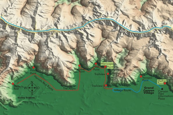
Trailview I and II provide more views of this trail and the village across the street. Trailview II is less frequented and actually has the better views.
Maricopa Point can be explored on either an east loop through a small juniper grove with views the entire length of the canyon to Dessert View, or a west loop with really good views in all directions.
Powell Memorial, as indicated above, is a bit of an insider’s tip and offers good views all around.
From Hopi Point, the Colorado looks like it’s filled with molten gold at sunset. It is the most popular point in the entire park to wait for sunset, and accordingly crowded at dusk. Start your work on the east edge of the terrace before the sun begins to set. The formations lying to the east will then bathe in the light of the already low sun, and there will be plenty of trees for you to include in the foreground. From the western edge of the platform, you can later include the cliffs lying in the foreground. If the sky in the west is refined by an interesting cloud formation, you should delay the return path a little. The best light in the clouds occurs only 15 min after sunset, and it is worth waiting for that. This position is also perfect, as the Colorado River reflects the light of the low sun from deep in the canyon and becomes visible as a silver band.
In any case, the large contrast range necessitates special attention to exposure. The analog photographer needs exact measurements with the spot meter and a set of graduated gray filters to master it. Of course, his digital colleague can work with this, but he has an advantage as he doesn’t have to worry about precise measurements. He makes his life easier by quickly taking a series of shots with correct exposure and +/- 2 exposure levels, which he then combines on the computer using Dynamic Range Increase to create a pseudo-High Dynamic Range Image (HDRI). „Pseudo“ because it is stored in an 8-bit format that provides only 256 brightness levels for each color channel. However, to store the actual range of brightness available in real HDR images, more bits or brightness levels are required. Under- and overexposure should be realized by lengthening or shortening the exposure time, but not by stopping down or up. The latter also changes the depth of field, and this is rarely desired. If the subject is moving too much, the following trick also helps when developing the image in RAW: Develop once on the highlights and once on the shadows, so that you have two images that have details in the respective areas. The image processing program then combines both to create a single image with the desired characteristics.
Mohave Point is shielded to the east by the cliffs of Hopi Point, so it lacks a view of the spectacular formations in that direction. It does, however, look down more directly on Colorado, reflecting in the twilight.
Up to Pima Point, there are now several unmarked parking bays on the Rim Drive from which you look across The Abyss, a horseshoe-shaped, 1000 meter-deep (3,280 ft) rockfall. Exposed at the top of a ledge, Pima Point offers a 180° panoramic view, making it an ideal spot for morning and sunset photographs of the formations to the west. It is also one of the points from which the river can be seen in the depth.
Hermits Rest marks the end of West Rim Drive and offers a wide view east into the canyon. Unfortunately, the formations are too far away for an impressive picture, and so the visit is only worthwhile if you really want to see all the points. To ensure a beautiful sunset, you should hit the bell in front of the kiosk blindly over the back with a stone throw – that brings luck!
Motifs east of Grand Canyon Village
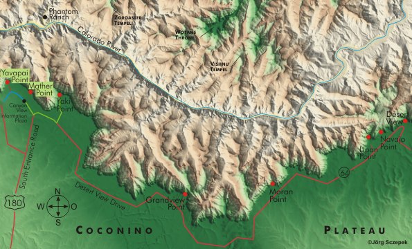
Yavapai Point competes with Hopi Point for the honor of the very best sunset. The only possible advice here is to reserve two evenings, as both are too spectacular to miss. To the east, from Yavapai, you have a unique view of the formations lying in the pink light, while at the same time, you can see the sun setting in the west. This time of day attracts a fair number of visitors. Along the Rim Trail, there are enough pine trees around the observatory to make up the foreground, and if the weather is not so good, you can at least enjoy the view through the observatory’s large glass windows.
Mather Point has very good views to the north and west. Sunrise is the ideal time to capture photographs, as the golden morning light illuminates the tops of the cliffs to the west. It regularly gets quite crowded here at this time. In spring and summer, you can capture an exciting teleshot as the sun rises near Shiva Temple.
Yaki Point is located at the end of a spur road off Rim Drive, from where the Kaibab Trail also branches off. It provides views of the central part of the canyon.
Grandview Point sits on an indented part of the Rim, limiting the view to the northwest and northeast. It is equally rewarding to visit in the morning and late afternoon.
Moran Point faces Grandview Point to the east, and its view is primarily to the northwest. Many nicely grown Pinyon Pines thrive in the vicinity of Moran Point, and you can include them in your pictures to document their survival, which involves sacrificing some of their parts. From the eastern edge of the canyon, there is an excellent portrait of the river with a rocky outcrop in the foreground and the Painted Dessert behind it.
Lipan Point boasts the most spectacular view to the west of any point on the south rim, with the river winding in a photogenic S-curve just below. Early afternoon is the best time to capture this part of the Colorado before it disappears into the shadows.
From Navajo Point, take a teleshot to include part of the lookout tower at Dessert View.
Dessert View Point is the last viewpoint on East Rim Drive in this sequence, and the observation tower, built in the traditional style of quarry stone, gives it special appeal. In the early morning, you can place it in front of the sunrise to enliven the foreground. The lookout itself, located at the top of the cliff, has a good view to the west and an even better one to the north of the great bend of the river around Cape Royal at the North Rim.
Motifs along the trails
For acclimatization, there’s the Rim Trail. The Rim Trail, which runs 15,2 km (9.5 mi) parallel to the rim from Yavapai Point near the Visitor Center to Hermits Rest at the very end of West Rim Drive, is fairly level and half of it is paved. You can walk it in stages and have the shuttle bus bring you back each time.
The Bright Angel Trail is well developed and is the trail that most visitors take, in addition to the mules (they go down here and come back up via the South Kaibab Trail). It starts at Kolb’s Studio, where West Rim Drive also has its beginning. The trip from Kolb’s Studio to Phantom Ranch spans 15,7 km (9.7 mi), during which you will descend 1347 m (4,420 ft) in elevation. You can stop or turn around after 2,4 km (1.5 mi) at the 1 1/2-mile resthouse (348 m / 1,140 ft difference in altitude), after 4,8 km (3 mi) at the 3-mile resthouse (591 m / 1,939 ft difference in altitude), and after 7,4 km (4.6 mi) at Indian Gardens (933 m / 3,061 ft difference in altitude). There is drinking water everywhere. Then the trail forks west to Plateau Point (9,8 km / 6 mi, 945 m / 3,100 ft difference in altitude), from where you have a wonderful view into the innermost part of the great canyon and further down to the Bright Angel Suspension Bridge.
The South Kaibab Trail, unlike the other trails, does not follow a side canyon but leads you straight down the rock ridges, which is why it offers direct views into the canyon. However, the trail can be particularly steep in certain areas and does not provide access to drinking water. The trail begins near Yaki Point on East Rim Drive and descends to Phantom Ranch, covering a distance of 11,1 km (6.9 mi) and an altitude difference of 1433 m (4,700 ft). After covering a distance of 2,4 km (1.5 mi) and a difference in altitude of 287 m (942 ft), you arrive at Cedar Ridge, a stunning viewpoint. The subjects primarily consist of panoramas, featuring the north rim prominently as the horizon for a change, and, in contrast to the viewpoints above, close-ups of the river. You only need to pack a wide-angle zoom to keep your equipment tolerably small and light. At the bottom, head west, parallel to the river, along the 2,4 km (1.5 mi) River Trail to the Bright Angel Trail. You can use this trail, which descends less steeply than before, to return to the South Rim. But only if you are still in good enough shape and have 5-6 hours of daylight left (29,2 km / 18 mi round trip).
In addition to these two well-maintained trails, there are also two unmaintained wilderness trails. Grandview Trail begins near Grandview Point on East Rim Drive and descends 4,8 km (3 mi) to Horseshoe Mesa (793 m / 2,600 ft difference in altitude). It features very steep sections and some tight switchbacks. Washouts and large rocks keep beginners away and provide enjoyable solitude. The Hermit Trail takes its start at Hermits Rest at the end of the West Rim Drive. It descends 13,6 km (8.4 mi) and 1293 m (4,242 ft) from here to the Colorado River. Santa Maria Springs is the turnaround point after 4 km (2.5 mi) and 488 m (1,600 ft) of difference in altitude. Before drinking, the water from these springs must undergo chemical treatment. If you encounter old mine shafts here, stay away. – There are high concentrations of harmful radon gas inside them!
Previous Photo Tips Grand Canyon NP
Next Photo Tips Grand Canyon North Rim
Next Photo Tips Toroweap Point
If you found this post useful and want to support the continuation of my writing without intrusive advertising, please consider supporting. Your assistance goes towards helping make the content on this website even better. If you’d like to make a one-time ‘tip’ and buy me a coffee, I have a Ko-Fi page. Your support means a lot. Thank you!
 Since I started my first website in the year 2000, I’ve written and published ten books in the German language about photographing the amazing natural wonders of the American West, the details of our visual perception and its photography-related counterparts, and tried to shed some light on the immaterial concepts of quantum and chaos. Now all this material becomes freely accessible on this dedicated English website. I hope many of you find answers and inspiration there. My books are on